
![]() The Loop (officially the Chuck Huckelberry Loop) is a wonderful mainly-flat ride along mixed-use asphalt paths around Tucson, with additional spurs heading out to other places. Much of the Rillito and Santa Cruz Rivers have paths on both sides, giving you a choice of which side to ride. Some of the ride is along paths that are well-used by walkers and cyclists, while other parts have a wonderful feeling of remoteness.
The Loop (officially the Chuck Huckelberry Loop) is a wonderful mainly-flat ride along mixed-use asphalt paths around Tucson, with additional spurs heading out to other places. Much of the Rillito and Santa Cruz Rivers have paths on both sides, giving you a choice of which side to ride. Some of the ride is along paths that are well-used by walkers and cyclists, while other parts have a wonderful feeling of remoteness.
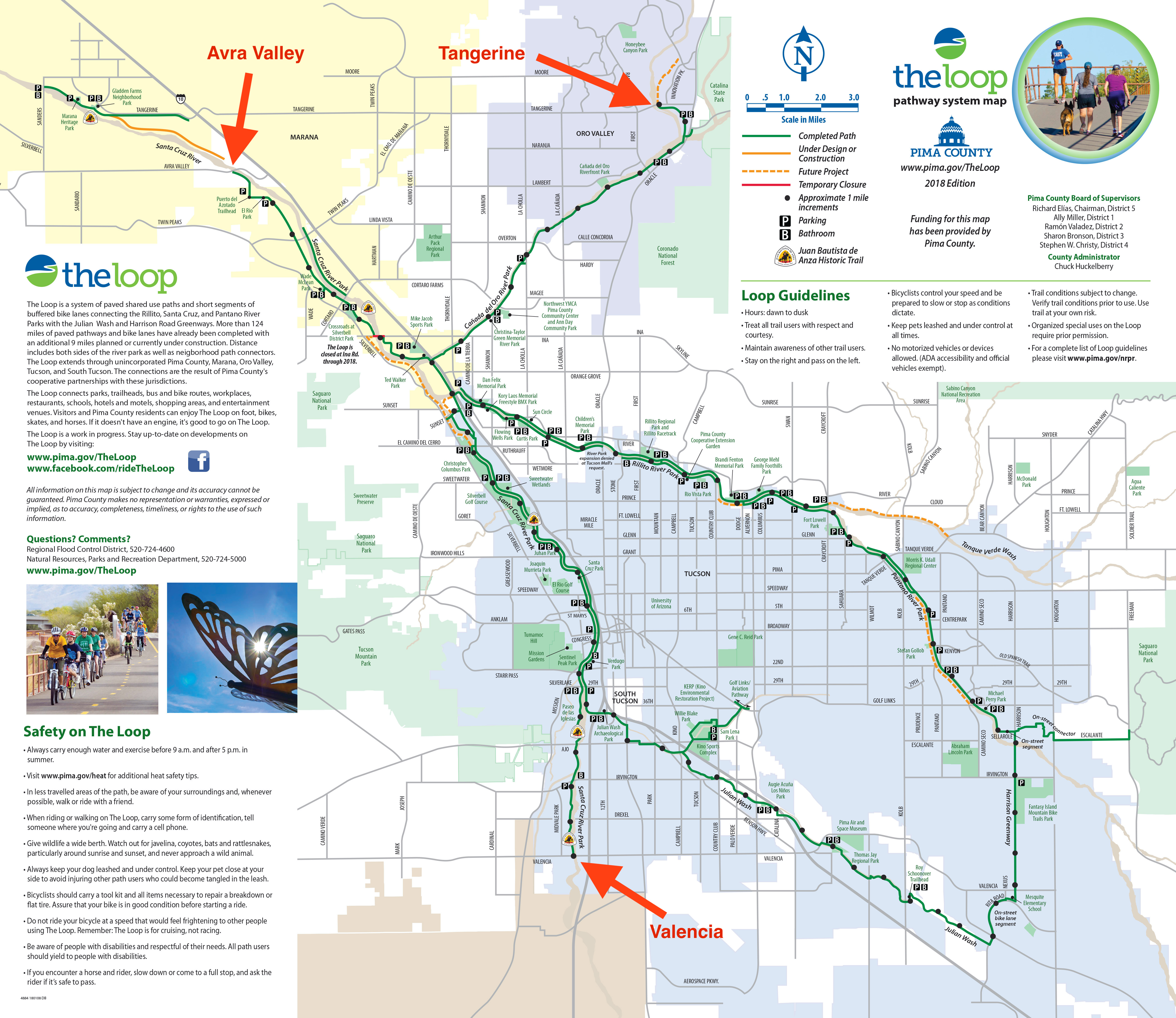
The main web page for the Loop claims (as of March 2020) that the Loop totals about 131 miles but this, somewhat sneakily, includes the paths on both sides of the Rillito and Santa Cruz rivers.
The actual “loop” part of The Loop is about 54 miles, and is a great way to circumnavigate much of Tucson. I’ve ridden it many times, in both directions, and in March, 2020 decided to also ride the three spurs to Tangerine Road, Avra Valley Road, and Valencia Road, which gives a ride of about 105 miles.
- The spur to Tangerine Road is about 22 miles out-and-back.
- The spur to Avra Valley Road is about 18 miles out-and-back.
- The spur to Valencia Road is about 10 miles out-and-back.
The vast majority of the “loop” is on wonderful mixed-use asphalt paths, and there are only a few miles of road (through South Tucson, and along Rita Road). However, at times it can be confusing trying to figure out which way to go, and I highly recommend carrying a map of The Loop (which you can pick up at most bike stores.)
I don’t think The Loop is very well signed, which adds to the difficulty of figuring out which way to go. The first time I rode the “loop” I got lost more than once in South Tucson and had to backtrack, even with a map. Sometimes on the “loop” there is more than one possible way to go, so again, a map is useful.
A few thoughts / points:
- The “loop” can be ridden either clockwise or counter-clockwise. Both directions are good.
- On the Rillito path, the south bank takes you through the Tucson Mall, which can be confusing. I prefer to be on the north side at this point.
- I prefer the west bank of the Santa Cruz River Path. The asphalt is newer than on the east bank and you don’t have to cross the road at Congress.
- There are a few places where you have to cross to the other bank to continue round the “loop”. I won’t describe most of them; you can figure out possibilities from the map.
- The two crossings I will mention are: a) Dodge is better than Craycroft to cross the Rillito. b) If you are going counter-clockwise and are on the west bank of the Santa Cruz River, cross to the east bank at Silverlake.
- If you are going counter-clockwise round the “loop”, at some point on the Rillito you need to get on the south path. Camino de la Tierra (a horrible road surface) is your last opportunity.
- If you do the spur up to Tangerine, you will be faced with many decisions points: right or left? Stay left at every decision point.
Links and Other Clicks
The main Chuck Huckelberry Loop web page
