
Update: 1/19/2021. I received this email from the Whipple Observatory Site Director:
The Mount Hopkins road is a public roadway up to the big metal gate at approximately kilometer marker 13. Beyond the gate (the paved section), access is restricted to authorized personnel only. We had a serious accident involving a cyclist about 2 years ago, and added signage to clearly indicate that access is restricted. We often “intercept” cyclists beyond the gate and politely send them back down the road. It would certainly help us keep everybody safe if you could edit your blog to mention that access beyond the gate is now restricted. That would be greatly appreciated.
Update: 2/5/18. I rode this again with friends and the photos are now all from the 2018 ride.
 The road up Mount Hopkins is another spectacular climb in the Tucson area. It’s the sort of climb that calls out to you when you hike up Mount Wrightson and look down at the beautiful white observatory sitting atop Mt Hopkins and see the steep road leading up to the observatory.
There are in fact several distinct telescopes at the Fred Lawrence Whipple Observatory and research into riding up this road can be confusing because when you find references to the Whipple Observatory, you are generally told about the Visitor Center at the base of the mountain. The white building at the top is the MMT (Multiple Mirror Telescope) Observatory – although the multiple mirrors have now been replaced by a single 6.5 meter mirror.
It’s a big climb, but since it’s a good road used by astronomers to get to their offices, it doesn’t have the feeling of isolation and big open skies that the Mount Lemmon Control Road has. The road is sometimes closed and you can generally find out about closures here.
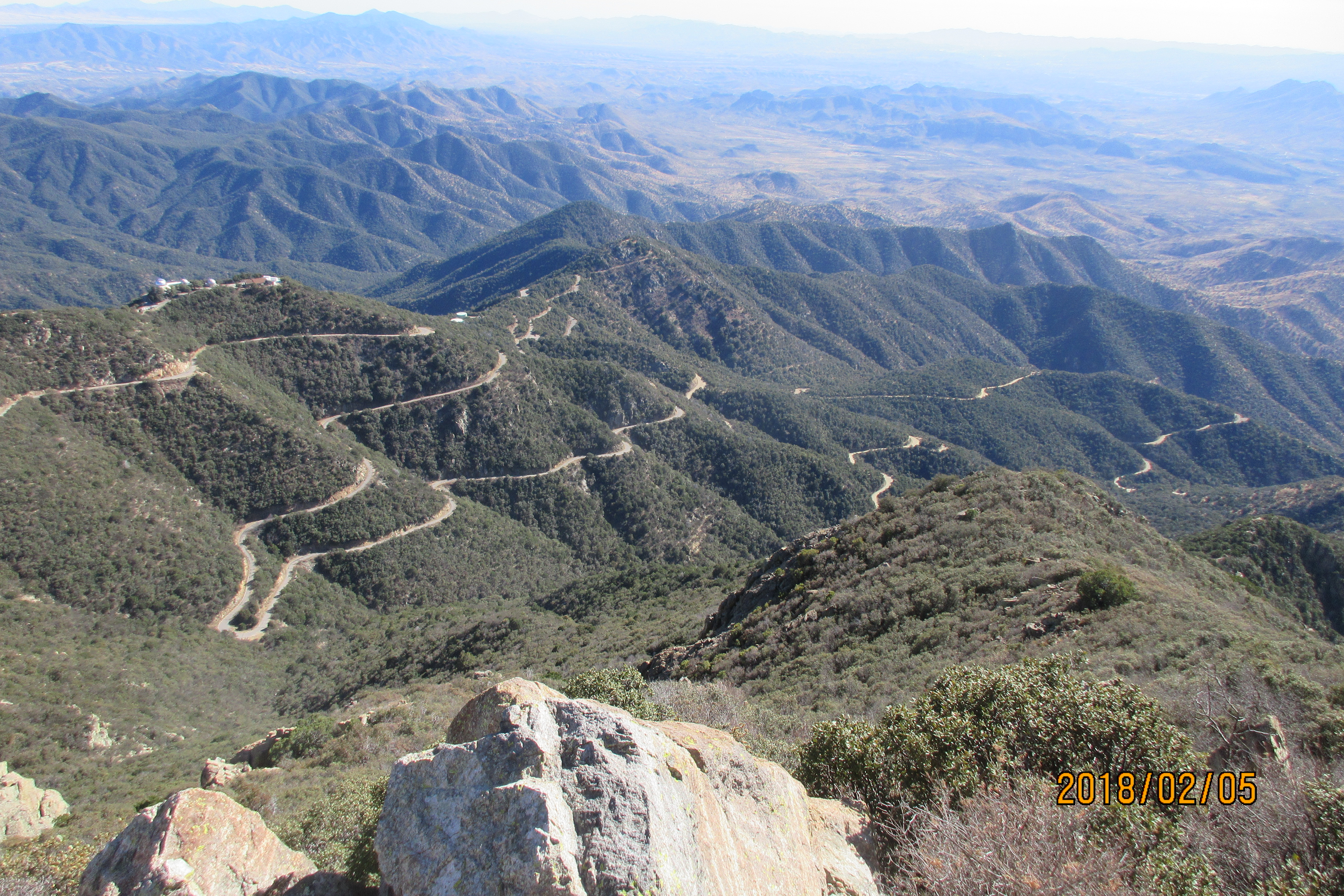
One of the fascinating things about this climb is that you see the MMT Observatory from many different angles. It hides and reappears, hides and reappears. Just when you think you must be getting closer it appears again from a different perspective and seems just as far away, but differently far away.
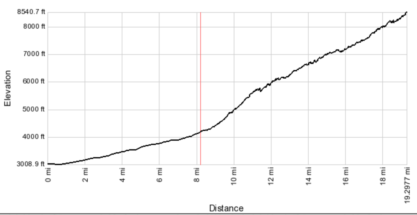
Elevation profile from Frontage Road
The red vertical line shows the location of the Whipple Visitor Center. It’s just over a thousand feet of gentle climbing from the frontage road.
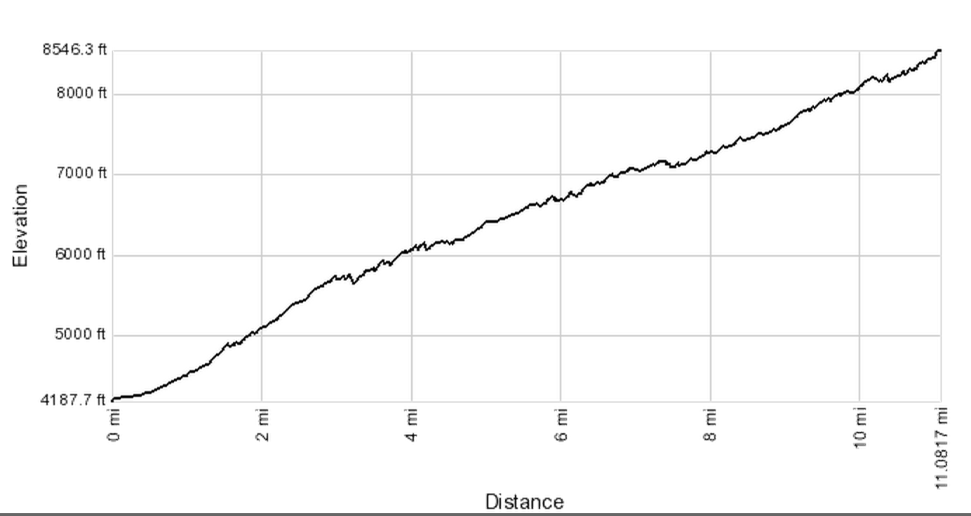
Elevation profile from Whipple Visitor Center
Google maps shows the distance from the Visitor Center to the top as being just over 11 miles. The kilometers markers by the road show the distance being 20 km, which is about 12.5 miles. Either way it’s a great climb 🙂
One Way Statistics
| Start | Miles | Feet Climbed | My Time |
| Whipple Visitor Center | 12.5 | 4,358 | 2 h 24 m |
| Frontage Road | 20.7 | 5,540 | 3 h 17 m |
Drive down I-19 past Green Valley to Exit 56 for Canoa Road. At the roundabout go left under the Interstate then turn right and go about three miles down the frontage road to Elephant Head Road. Turn left and park in the large dirt area on the right.
It’s about 8 miles of gradual uphill from here to the Whipple Visitor Center. Ride along Elephant Head Road for 1.5 miles then turn right on Mt Hopkins Road, following the signs for Whipple Observatory.
 When you reach the Visitor Center the real climbing starts; everything so far has just been a warmup. In fact, another option is to drive to the Visitor Center and park there, and many people do just this.
From the Visitor Center to the very top, the distances are marked at the side of the road in kilometers, with a sign every half kilometer. The top is at the 20 Km mark. You always know how far you have climbed and how far you still have to climb.
 The road immediately turns to dirt and continues as dirt for around a kilometer, then switches back to pavement. Then a short way after Km 2, it goes back to dirt and continues as dirt for the next 10 km, until just after Km 12.5, when it changes back to pavement for the rest of the climb. So the climb has approximately 7 miles of good dirt road, which would make this ride a good candidate for a gravel grinder bike.
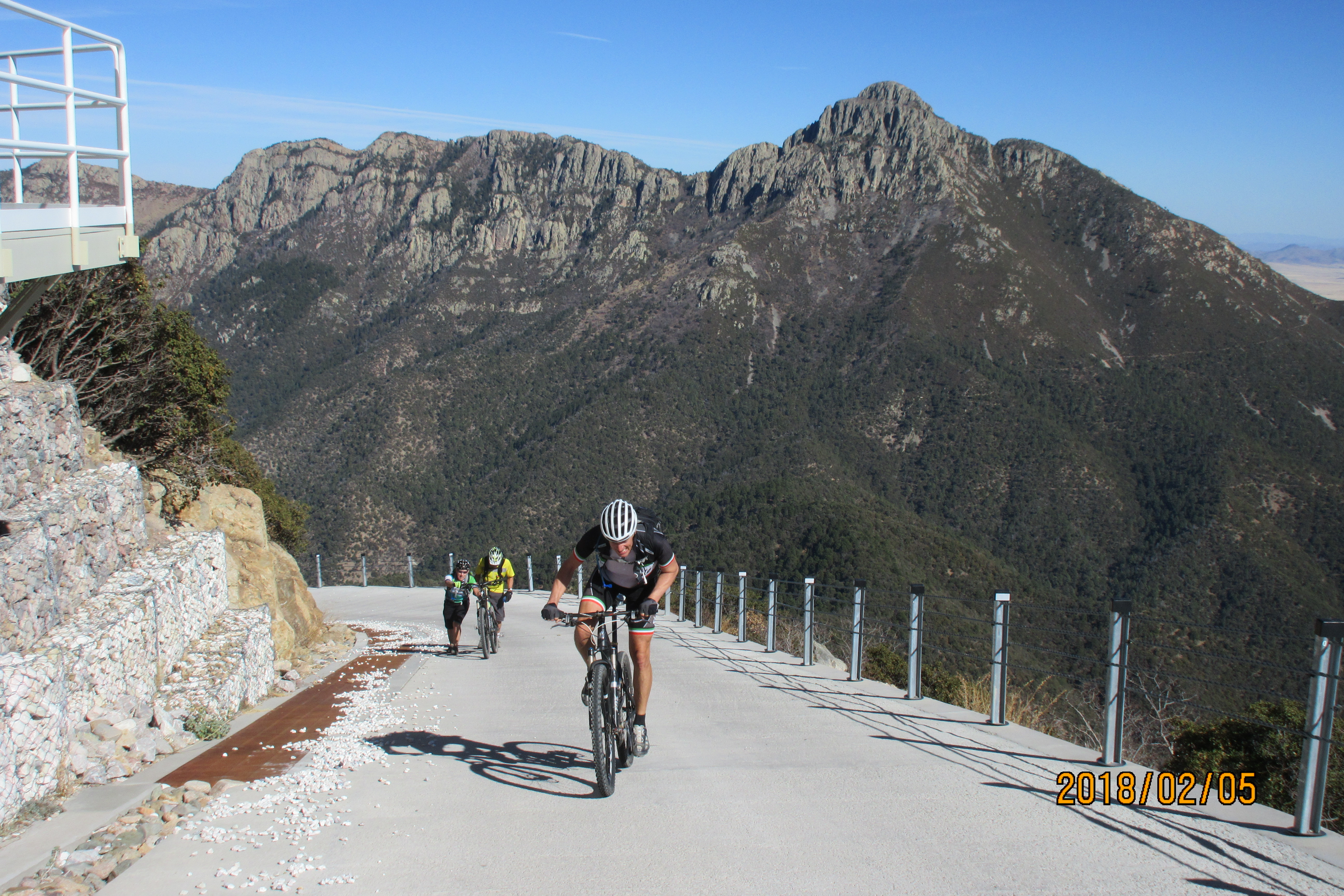
The final brutally steep climb to the top. Mt Wrightson is in the background.
Just after Km 13 there is a gate but you can walk around this on the left. At Km 17 you are finally below the summit block and you head left up the switchbacks to the summit, which you reach at Km 20. The final few hundred feet below the summit are the steepest on the climb.
I rode this on May 29, 2014.

Do you think the dirt would be too rough for standard road tires? Both ascending and descending? I’m thinking about attempting this one this week.
Thanks!
LikeLike
Last time I rode Hopkins the road was very well graded so I don’t think it should be a problem. But I can’t promise anything as it was a few years ago since I rode it 🙂
LikeLike
Road bike tires are good UNTIL you get past the Hopkins observatory. I struggled on a cyclocross bike with 33s. I have a 38 gravel and it is ideal. The Arizona Bicycle Association at BikeAZ.org ranks this has a must do gravel bike ride. Many will use a rigid or front shock bike.
LikeLike