
Many of the rides are climbs described in John Summerson’s book, The Complete Guide to Climbing (by Bike). When describing one of these climbs, I include (S-#) in the name to indicate that the ride is described in his book. The # shows the climb’s category given by Summerson (1, 2, HC=hors categorie). When I describe a climb, the distance is usually one-way, to the top.
Note: MM = Mile Marker
Las Vegas
Kyle Canyon (S-1 or S-HC/1)
 A long and rather tedious climb up Hwy 157, heading up towards Mount Charleston, just north of Las Vegas. Depending on the finish you do, the climb is either about 21 miles with 4,860 feet of climbing, or 22.2 miles with 5,500 feet of climbing. If you do both finishes, you can expect about 25.7 uphill miles with 6,440 feet of climbing.
Drive north from Las Vegas up Hwy 95 for about 10 miles. Take the exit for Hwy 157 following signs for Mt Charleston. Park in an obvious parking area on the right hand side of 157, a few hundred yards up from Hwy 95.
For almost nine miles, climb the very straight, rather tedious and gentle climb to a big parking area and viewpoint on the right. After a very short downhill the road enters a shallow canyon and begins to curve a bit and become more interesting.
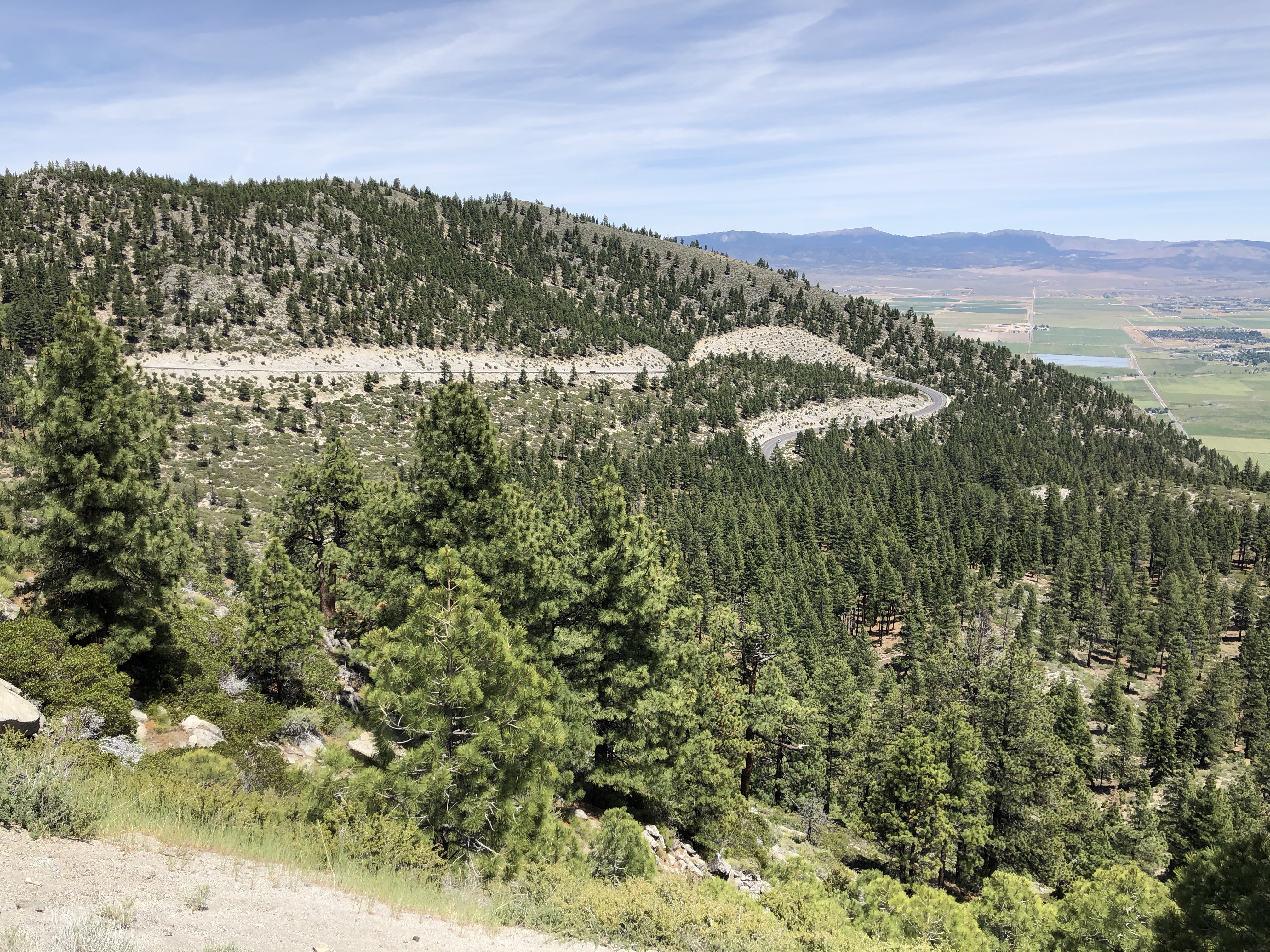
Just over 17 miles and 3,900 feet of climbing from the car, after another short downhill, Hwy 158 turns right, signed to Lee Canyon. At this point you have a choice.
The better finish is to turn right and follow 158 as it slashes across the hillside then does two huge switchbacks before reaching the crest of the hill after 4.8 miles and 1,580 feet of climbing. There is a large paved parking area on the left – the North Loop Trailhead. Turn around here and head back. Hwy 157 with this finish is rated HC/1 by Summerson.
The other option is to ride up into the town of Mount Charleston and continue to the end of the road where it loops around. This is a less steep finish, and more heavily trafficked. From the intersection of 157 and 158 to the end of the loop is 3.6 miles with about 940 feet of climbing (this includes the short climb back out from the loop.) Hwy 157 with this finish is rated Category 1 by Summerson.
Of course, an obvious choice is to do both finishes since you’ll probably never do the initial climb again. If you do this, I would suggest doing the 158 finish first as you are less likely to want to do this finish on the way down from the town of Mt Charleston.
Lee Canyon (S-HC)
I’d previously ridden Lee Canyon several years before I started these web pages, so don’t have any photos or details to write about. That said, drive north from Las Vegas up Hwy 95 for about 25 miles. Turn left on Hwy 156, Lee Canyon, and park.
Hwy 156 is a big ride, about 17.3 miles with 5,348 feet of climbing. According to John Summerson it’s perhaps the most difficult climb in Nevada.
Lake Tahoe
Tanya and I spent a week in South Lake Tahoe, CA, in June 2020, but the two big climbs I did are in Nevada, hence on this page. I’d hoped to ride around the lake but after seeing the amount of traffic and the lack of shoulders, I decided against doing the ride.
Mount Rose (S-1)

Climbing the West side
Mount Rose is the biggest climb over the Lake Tahoe rim, going up to 8,911 feet. It’s the highest pass over the Sierras that stays open year-round. The over-and-back ride from Hwy 28 on the west, to Interstate 580 on the east, is 49.3 miles with about 6,500 feet of climbing.
(We started a more interesting and peaceful way than Summerson describes, so I’ll first give Summerson’s statistics.
West side, from the intersection of Hwy 28 and 431: 8.1 miles with 2,528 feet of climbing.
East side, from somewhere around Hwy 395: 16.1 miles with 4,349 feet of climbing.)
Park south of Incline Village on Hwy 28, at the big parking area by the Tunnel Creek café.
Ride north for about 0.6 miles, then at the traffic light turn right on Country Club Drive (remember this name as you’ll be looking for it on the way down.) Turn right again in 100 yards on Ski Way. At 1.6 miles turn left, then make a slight right on Fairview Blvd and follow this all the way to 431, which you reach at about mile 4.25. This is not as complicated as it sounds, and it provides a much more peaceful ride than starting up 431.
One you’ve joined 431, turn right and continue up to Mount Rose Summit which you reach at about mile 9.4, having climbed about 2,500 feet. There is a wide bike lane, and the gradient is fairly consistent at 6% with some 7%, and you’ll pass a viewpoint offering spectacular views of Lake Tahoe and the mountains beyond. Shortly below the summit there’s even a short downhill.
Ride down the east side with some beautifully fast and sweeping turns for about 10 miles until the road widens and becomes a 4-lane road and you enter a much more residential area. Continue down for about another 5 miles until you reach the overpass of Interstate 580. This is where I turned around.

The East side, Mount Rose up ahead
Ride back up the 4-lane road at about 5%, with a good, wide bike lane, until at Timberline Drive the road changes back to two lanes, and the traffic thins out a bit. There can still be quite a bit of traffic heading over to Lake Tahoe, but the bike lane from here to the top is generally about 2 feet wide, sometimes more, occasionally less.
In just over 10 miles from here, many turns and switchbacks later, sometimes with views of Mount Rose looming over you, you’ll gratefully reach Mount Rose Summit again, having climbed about 4,000 feet on this side. The gradient on this upper section is mainly around 6%, with a small amount of 7%, and a brief section of 8%.
Ride back down the West side, and after about 5 miles turn left on Country Club Drive. A steep descent takes you back down to the traffic light where you originally left Hwy 28. Turn left and ride just over half a mile to your car, after a satisfying day out.
Kingsbury Grade (S-1)
 This is a good ride with easy access from South Lake Tahoe, where we were staying. The whole over-and-back ride is 22.2 miles with about 3,550 feet of climbing. The west side is 3.2 miles with almost 1,000 feet of climbing. The east side is 7.9 miles with about 2,550 feet of climbing, and feels much bigger and more alpine.
Start at the bottom of Hwy 207, about 1 mile north of Stateline on Hwy 50. Getting there from South Lake Tahoe was terrifying, with lots of traffic and no bike lane.
Climb up Hwy 207 for about 3.2 miles with 1,000 of elevation gain, including some 8%, to Daggett Pass. The road has some nice bends, and mainly has a decent bike lane, but it climbs through a fairly residential area, which I found quite dangerous on the way down with cars turning into side streets.
At Daggett Pass, you can see the flat plain down below you, and a fast descent with big sweeping turns takes you down to the flats in about 8 miles. The descent finishes abruptly where Hwy 207 meets Hwy 206. There is a huge Park ’n Ride at the intersection.
Turn round here and ride back up the long climb to Daggett Pass. As you start the climb you can look down into the lovely village of Mottsville with its beautiful houses. The climb is big and steady, with a good bike lane, and has a short section of 9%. After several big sweeping turns, a long straightaway eventually leads you back up to Daggett Pass. Make your way back down to Lake Tahoe, watching out for turning traffic.
