
July 2015, August 2019
KmM = Kilometer Marker
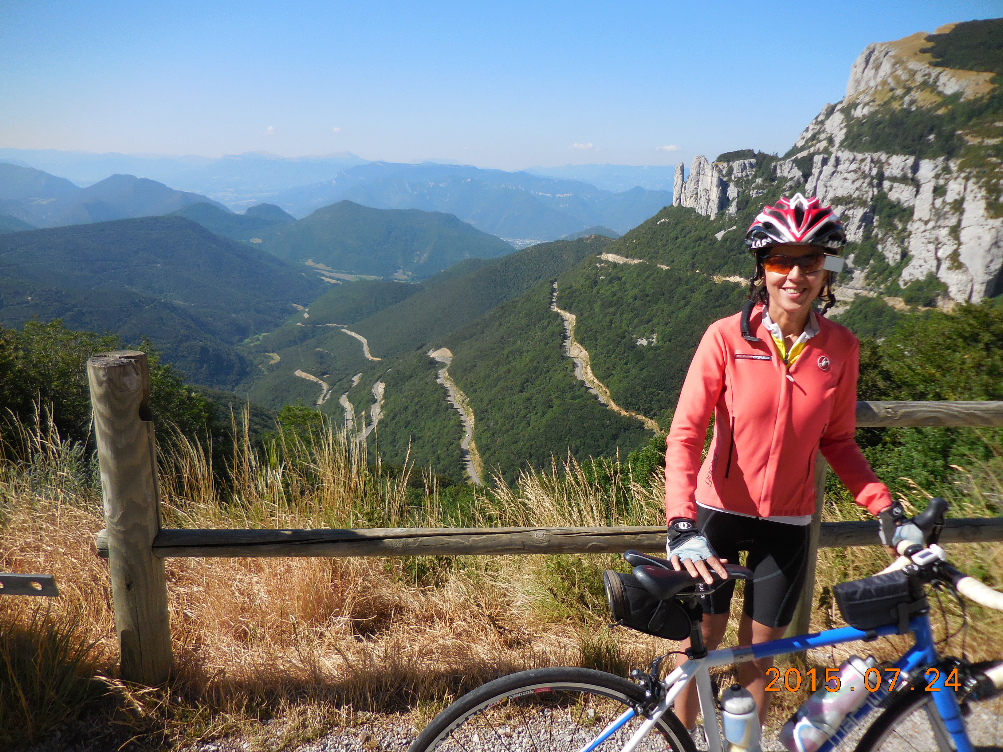
We stayed in Lans-en-Vercors for about ten days in 2015, but there’s not much real climbing nearby, so we drove to all the rides. I drove to Le Bourg d’Oisans twice, once with Tanya to ride Alpe d’Huez and watch the TdF, and once by myself to ride a few other climbs. We drove to ride the Col de Rousset, the Col de la Machine, and the Col de Porte. I wrote about the climbs in Le Bourg d’Oisans in their own section, but the others are just included here. In 2019 I added a wonderful loop in the Chartreuse mountains, which are to the NW of Grenoble.
Vercors
Col de Rousset
About 20 km one-way and 858 meters (2,815′) of climbing. A lovely climb, never very steep, but in wonderful surroundings. We discovered this by chance as we had to drive over it on the way to where we were staying in Lans-en-Vercors. Start in Die and follow the road north, finishing at the tunnel. Or start at the tunnel and ride down to Die and back.
Col de la Machine
There are two main climbs up to the Col de la Machine. Here they are:
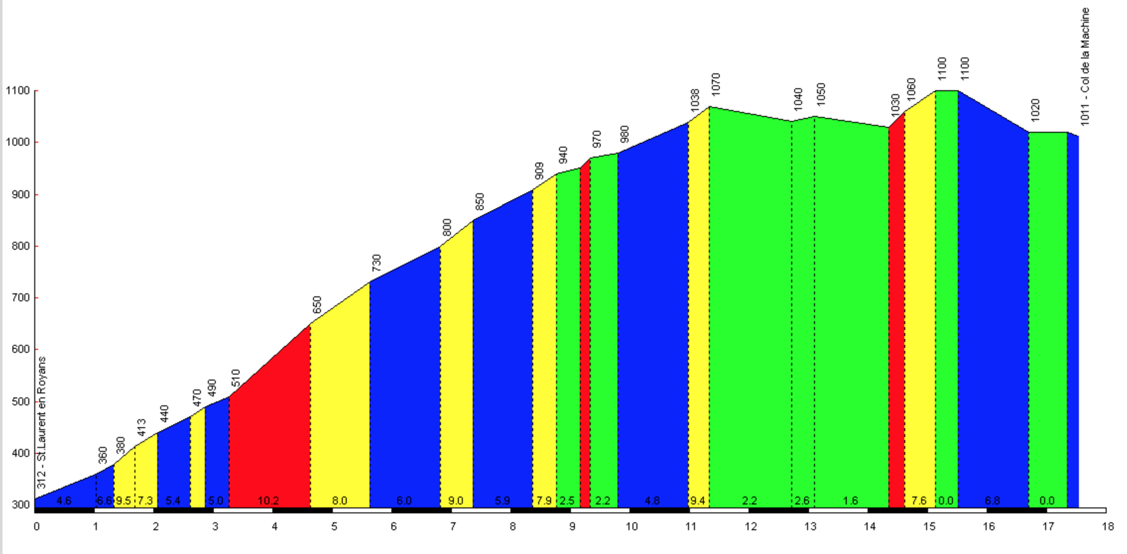 From Saint-Laurent-en-Royans. About 17 km and 850 meters (2,789′) of ascent. When I was looking for climbs to do around Lans-en-Vercors, I came across this profile on ClimbByBike.com. It has the most colorful profile that I’ve seen and for that reason I wanted to ride it. It’s a pleasant ride if you are in the area, not too hard, with little traffic, but no great views. There are two unlit tunnels, one of 120 meters and one of 255 meters. Lights are useful but not essential – there is just enough light to make your way through the longer tunnel.
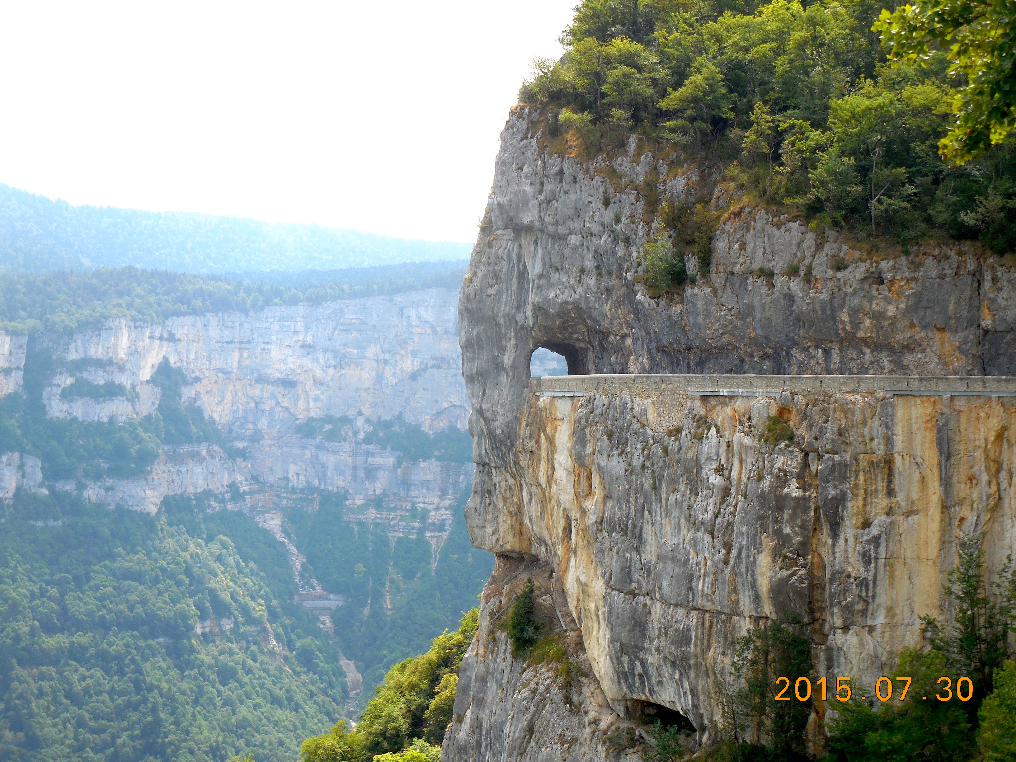
From Saint-Jean-en-Royans. About 12.25 km and 770 meters (2,526′) of ascent. After doing research on Col de la Machine I discovered that the climb from Saint-Jean-en-Royans was written up in dangerousroads.com as being one of the most spectacular balcony roads in France. (It is written up twice: as the Combe Laval Road and as the Col de la Machine Road.) This of course meant we had to ride it. The first 8 km are pleasant with no surprises and a good road surface, but the 3 km of balcony road are just stunning with tunnels, cliffs, overhangs, narrow roads, and incredible views of the cliffs and the valley to the side. There is one lit tunnel of 190 meters.
Grenoble to Saint-Nizier-du-Moucherotte
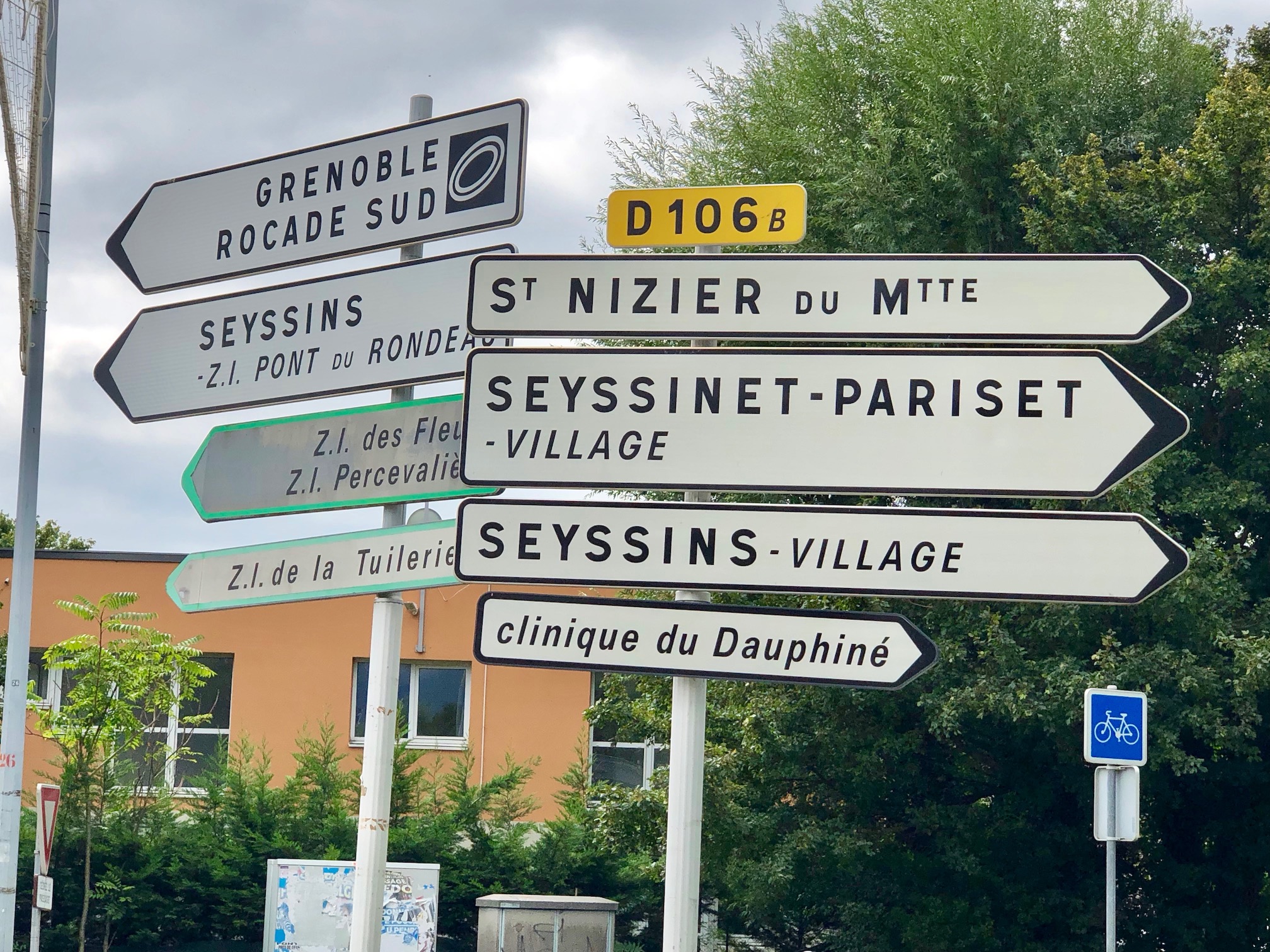 There are two roads up to the Lans-en-Vercors part of the Vercors plateau: the D531 and the D106. The former is a much faster and busier road and I doubt much fun to ride. The D106 is a much better road for riding up to the plateau from Grenoble. It’s not as much fun as some of the quieter or prettier roads, but it does give you about 14.4 km and 919 meters (3,015′) of climbing.
Start at the roundabout where the D6 and D106B meet (coordinates
45.176126,5.686879). Follow the D106B then D106 uphill to Saint-Nizier-du-Moucherotte.
There’s another start to the climb starting at (45.167696, 5.690662) but I have not done that start.
Miscellaneous
There are a few short climbs of 3-7 km up on the plateau around Lans-en-Vercors and Villard-de-Lans, leaving the plateau valley and heading up to ski areas. Here are a few:
- One leaves Lans-en-Vercors and climbs to the local ski area at La Sierre.
- Another climbs to the Villard-de-Lans ski area, climbing up past Le Balcon to Les Glovettes.
- A better way to Les Glovettes, up quieter roads, is to climb up past the Lycée Climatique to Les Clots then Les Glovettes.
- Another climbs to Corrençon and continues up past the golf course to the ski area.
Other Cols
Too late I discovered a list of Cols in the Vercors on Wikipedia. Here they are, listed by altitude of the col, and showing the towns or villages at both ends. I wish I’d seen this sooner as it would have given me lots of ideas for rides. Instead, I went hiking 😀.
- Col du Mont Noir, 1,421 m, between Malleval-en-Vercors and Rencurel
- Col de l’Allimas, 1,352 m, between Gresse-en-Vercors and Saint-Michel-les-Portes
- Col de la Chau, 1,337 m, between Vassieux-en-Vercors and Bouvante
- Col de la Bataille, 1,313 m, between Léoncel and Bouvante
- Col de Rousset, 1,254 m (tunnel altitude), between Die and Saint-Agnan-en-Vercors
- Col de Saint-Alexis, 1,222 m, between Vassieux-en-Vercors and Saint-Agnan-en-Vercors
- Col de la Croix-Perrin, 1,218 m, between Lans-en-Vercors and Autrans – Méaudre
- Col de Carri, 1,202 m, between La Chapelle-en-Vercors and Bouvante
- Col de la Portette, 1,175 m, in Bouvante
- Col de l’Arzelier, 1,154 m, between Château-Bernard and Le Gua
- Col de Tourniol, 1,145 m, between Léoncel and Barbières
- Col de Proncel, 1,100 m, between Vassieux-en-Vercors and La Chapelle-en-Vercors
- Col des Limouches, 1,086 m, between Léoncel and Peyrus
- Col de Romeyère, 1,069 m, between Rencurel and Saint-Gervais
- Col de la Machine, 1,011 m, between Saint-Jean-en-Royans and Bouvante.
Chartreuse
Chartreuse 4-Col Loop
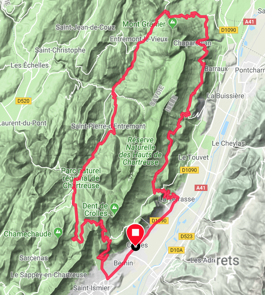
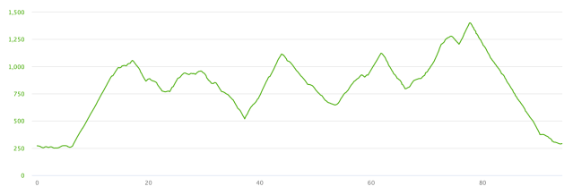
This is a fantastic loop through beautiful country, of 94 km with 2,860 meters (9,383′) of climbing. It goes over 4 cols: the Col de Marcieu, the Col du Granier, the Col du Cucheron, and the Col du Coq.
I did the loop counter-clockwise as described on Cycling Challenge (you can also see profiles of the four climbs done counter-clockwise there) and loved it so much I went back a few days later and rode it clockwise.
Both ways are beautiful; counter-clockwise you get the most consistently steep climb (Col du Granier) and the climb with the steepest sections (Col du Coq from the west), while clockwise you get the longest climb (Col du Coq from the east) and the most tedious section (Col du Marcieu from the bottom of the Col du Granier).
Which way should you do it? As I said, both ways are good, but if I had to choose I would say counter-clockwise. That way you get the brutal Col du Granier and the super-steep sections on the Col du Coq 😀.
Left to Right: Marcieu, Granier, Cucheron, Coq
For both rides I parked at the Place Alfred Berthet in Crolles, where there is plenty of parking.
Counter-Clockwise

The route is well-signed and you should have no problem finding your way.
Ride north on the main road until at about km 5.4 turn left to La Terrasse. Turn left on the D30 and climb the 7 km of steep zig-zags to Saint Bernard du Touvet. As you enter the village turn right on the D30c signed to Col de Marcieu, which you reach at about km 17.
Continue until at about km 24 you leave the D30c and continue straight on the D282, signed to Sainte Marie du Mont. More climbing then a long descent takes you to an intersection at about km 37. Turn left here following the sign for the Col du Granier.
7 km of misery, including one kilometer averaging 11.3% and another averaging 11.7%, and you arrive at the Col du Granier. On this climb I was overtaken by an elderly gentleman on an e-bike, who seemed to be enjoying himself. I can see an e-bike in my future 😀.
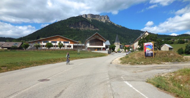
Now you have 10 km of reward, a lovely descent down a beautiful, wide open valley, with the distinct peak of Chamechaude beckoning in the distance. My one regret on the ride is that I didn’t stop in this valley to take photos – the descent was too much fun 🙂 The ascent also looks fun and I saw more people riding up this valley than on any other part of the loop.
Down in Saint-Pierre-d’Entremont, turn left on the D512, then left again on the D512 at the city limits, following the signs for Saint-Pierre-de-Chartreuse. You’ll reach the top of the Col du Cucheron shortly before km 62 – fortunately this climb is not as steep as the previous two climbs.
Just below Saint-Pierre-de-Chartreuse, at about km 66, turn left, staying on the D512, signed to Saint-Hugues-de-Chartreuse and the Col de Port. In about one kilometer, turn left again on the D57B, signed to Saint-Hugues-de-Chartreuse and the Col du Coq.
Just after Saint-Hugues-de-Chartreuse the road splits, with the D57B turning right. Your road, up to the Col du Coq goes straight, up the C8. The road narrows and becomes quite a bit rougher, with gravel on the road in places. There are some steep sections on this climb, including one section of 16%. Fortunately there’s a 2 km downhill before the final 2 km to the Col du Coq.
From here a steep descent leads in about 6km to the D30 where you turn right towards Grenoble. Down at the D1090 turn left and follow the mainly flat road back to your car. My legs were exhausted by the finish.
Clockwise
 This way is a little less well marked than counter-clockwise and you’ll have to pay a little more attention to the intersections.
Head south on the main road, gently uphill, for 4.1 km, where you turn right on the D30 signed to St Pancrasse and Ste Hilaire du Touvet. This climb is the longest climb of the day, at about 12 km. The first 6 km each average in the 8-9% range. There are 500 meters of tunnel on this section, but the tunnels are lit and have climbing lanes.
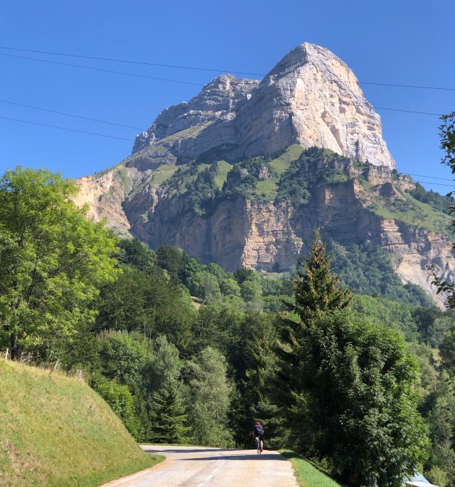
At about 10.5 km turn left on the D30E signed to the Col du Coq. The road opens up, the views improve, and there are fantastic views of the towering Dent de Crolles as you ride up towards it. This section has 3 successive kilometers of 9.1, 9.1 and 9.2%.
The descent of the Col du Coq has some very steep sections, and when I did it there was gravel on the road in paces. Interestingly I saw more people climbing this side of the Col du Coq than I saw on any other climb this day. Near the bottom of the descent the road splits – take the left branch signed to Hugues. Then at about km 27 turn right on the D512 to Saint-Pierre-en-Chartreuse then Saint-Pierre-d’Entremont, climbing over the Col du Cucheron.
In Saint-Pierre-d’Entremont the D512 becomes the D912 signed to Entremont-le-Vieux. Follow the D912 to the Col du Granier, up a long not-too-steep climb through beautiful country. Immediately past the Col du Granier, turn right and descend steeply for about 7 km to a sharp left-hand switchback. At this point the D285 heads off to the right, signed to Sainte-Marie-du-Mont in 11 km.
This next section to the Col de Marcieu has everything: gentle uphill, flats, a couple of good downhills, steep uphills, and even a short section of 13% into the village of Bellecombe. But the thing you’ll most notice is that it’s about 20 km with a lot of uphill.
From the Col de Marcieu, descend into Saint-Bernard-du-Trouvet. The obvious left turn is no-entry, so continue a bit to the next left turn and go down to join the D30. Turn left on the D30 and descend to La Terrasse. Turn left in La Terrasse and ride through the village until you join the D1090 and ride south back to your car after a tough but rewarding day.
Col de Porte
 About 15.5 km and 1,100 meters (3,609′) of climbing. Not a very inspiring climb, and only worth doing if you are in the area. Tanya’s view is that you’d have more fun having a coffee and a pastry. We parked in Grenoble, near the Bastille, by the river just before the city limit sign for La Tronche. Ride into La Tronche and soon turn uphill on the D512 following the sign for Col de Porte.
