
September, 2019
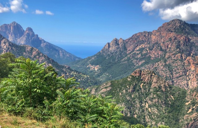 Corsica is a very dramatic island, with some spectacularly rugged terrain, which makes it a fantastic destination for hiking and cycling. One of the hikes, the GR-20, is perhaps the best and hardest multi-day hike in France.
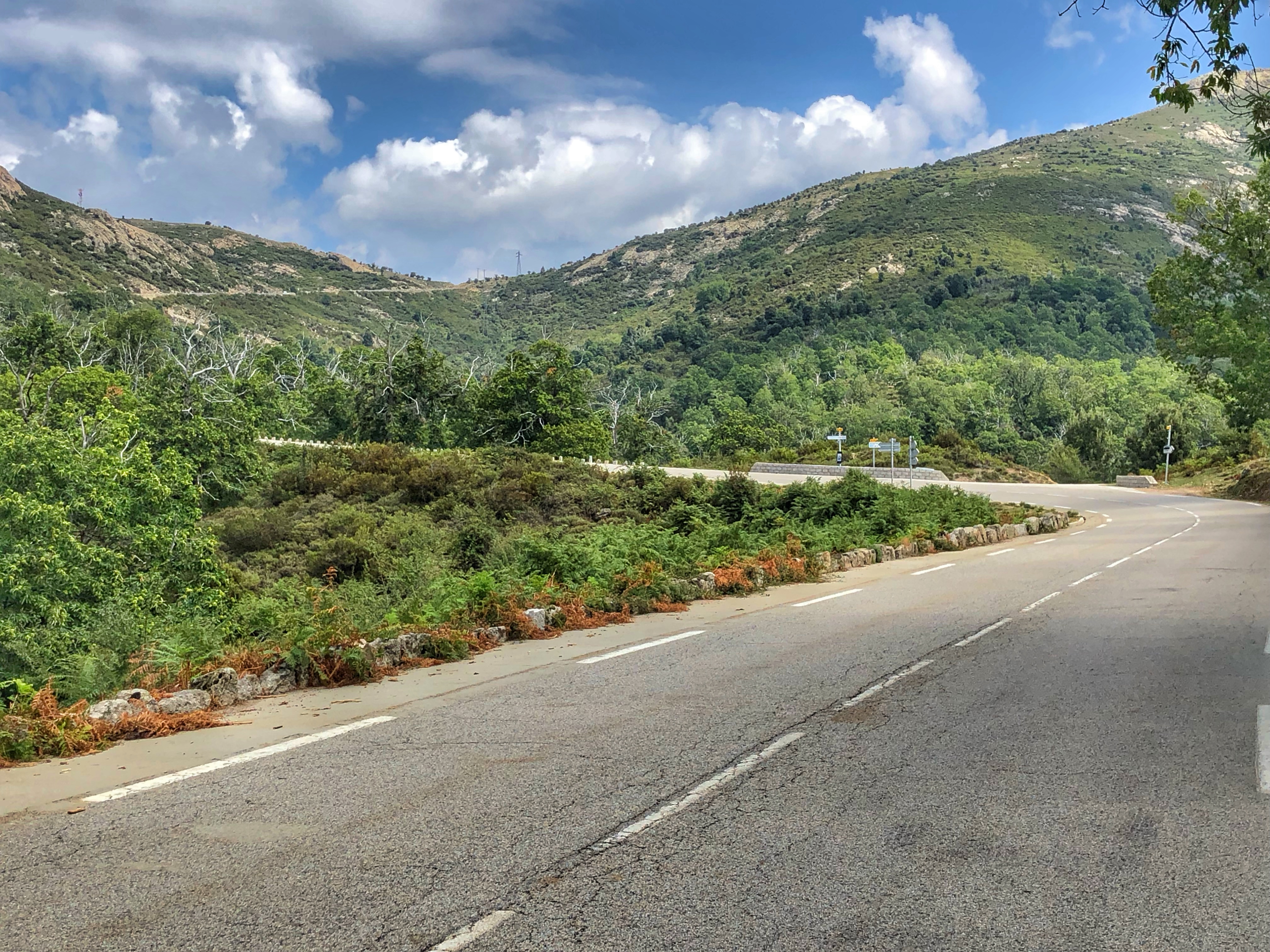
If you look at a map of Corsica you’ll see many, many little twisty roads. Some of the smaller roads winding into the hills are one-lane roads masquerading as two-lane roads; fortunately they are wide enough for a car and bike 😀. Most towns have two names: a French name and a Corsican name, and you’ll often see one name spray painted out as a political statement.
Porto
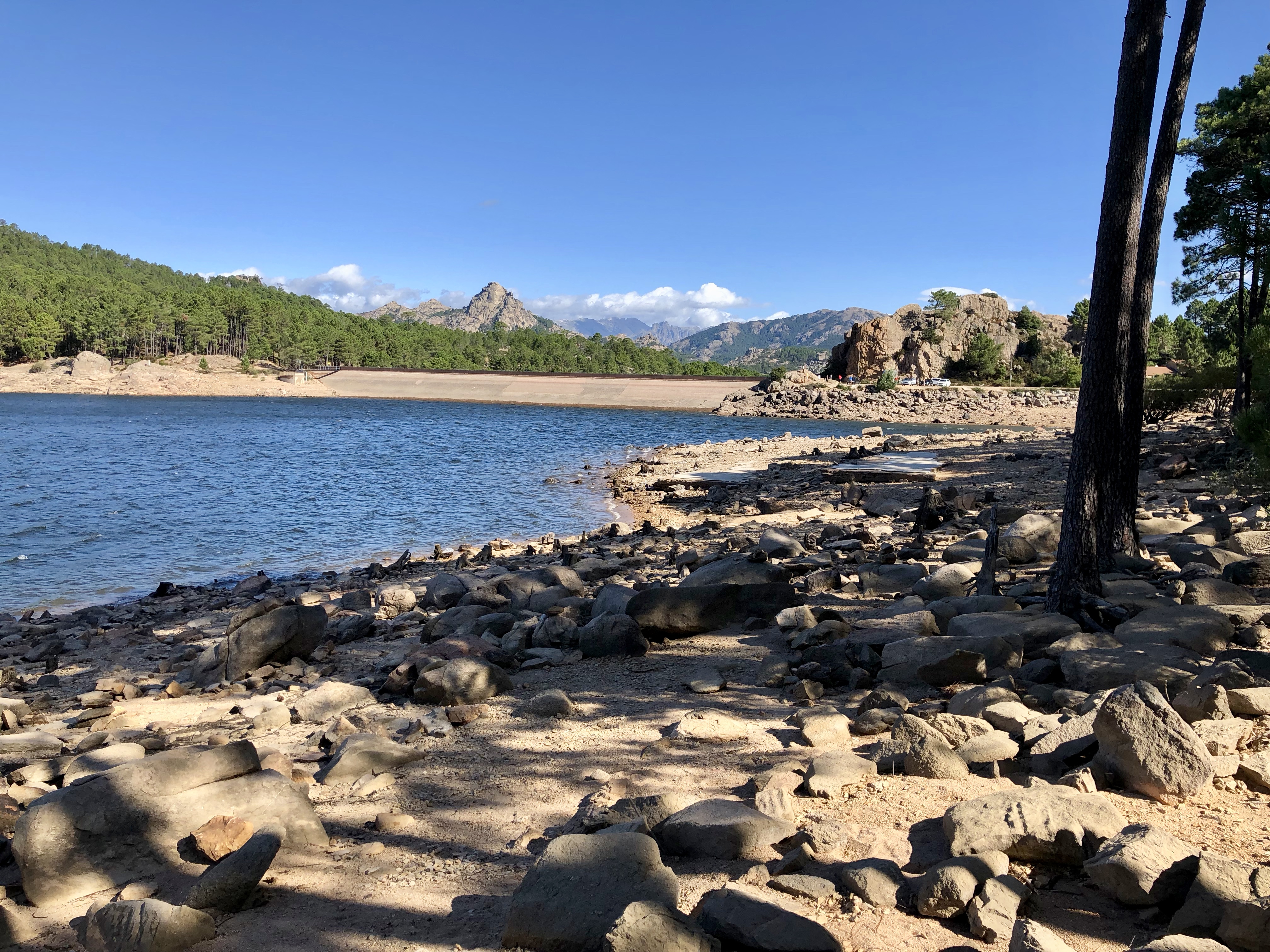
Porto is a lovely little town on the West coast of Corsica, bustling with tourists. We’d expected it to be small and quiet, but the road to the marina is lined with hotels, restaurants, and beautiful eucalyptus trees. At the top of the Marina road are two supermarkets that are open all day, every day: Spar and Carrefour Contact. There’s also a store across the road from the supermarkets that rents out bikes and e-bikes. We were surprised at just how impressively commercial it all is, and how many boat tour companies are vying to take you on tours of the spectacular rocky coastline.
There are basically three roads out of Porto: the D81 to the north, the D81 to the south, and the D84 to the east.
Col de Vergio – West Side
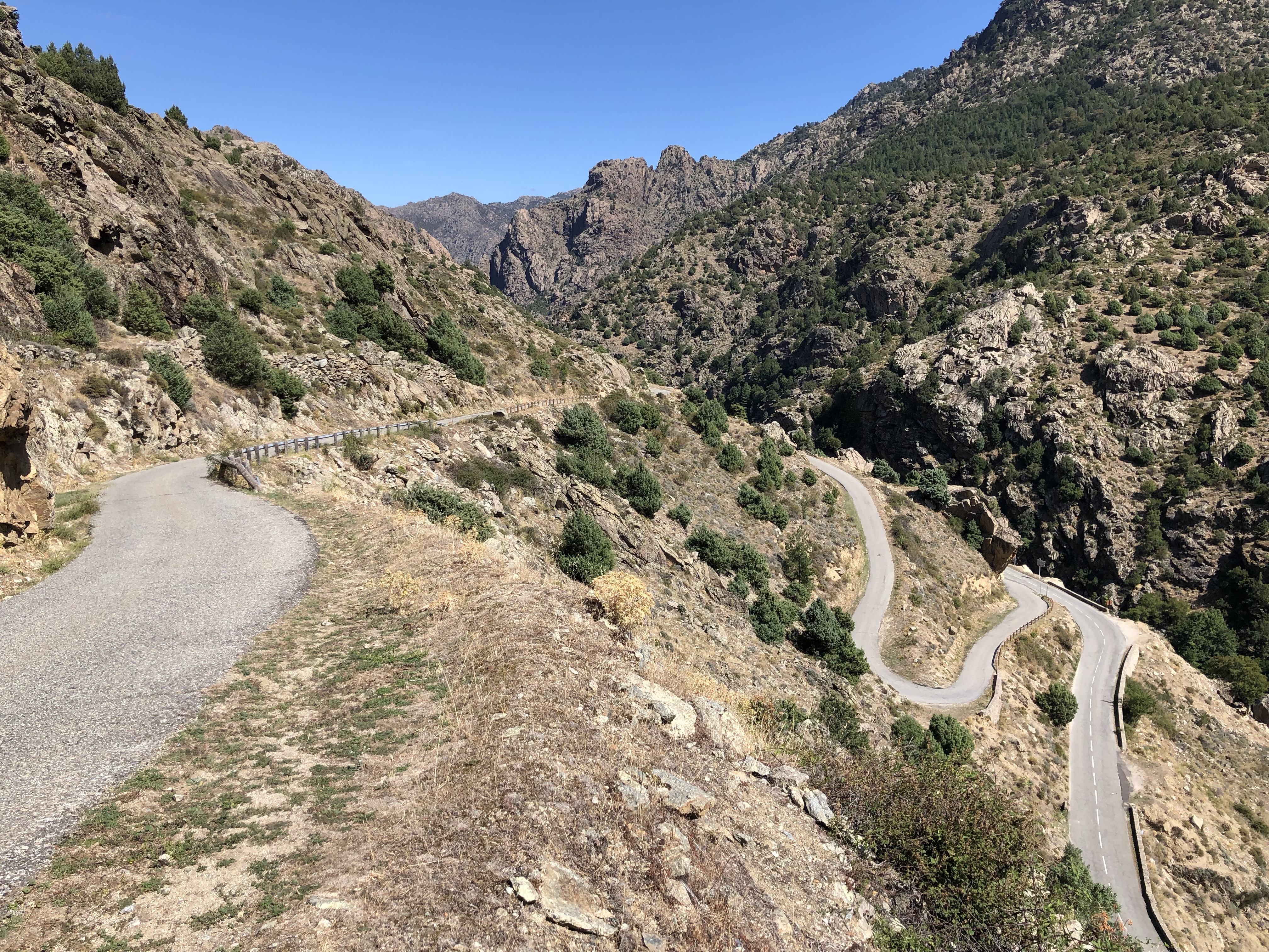
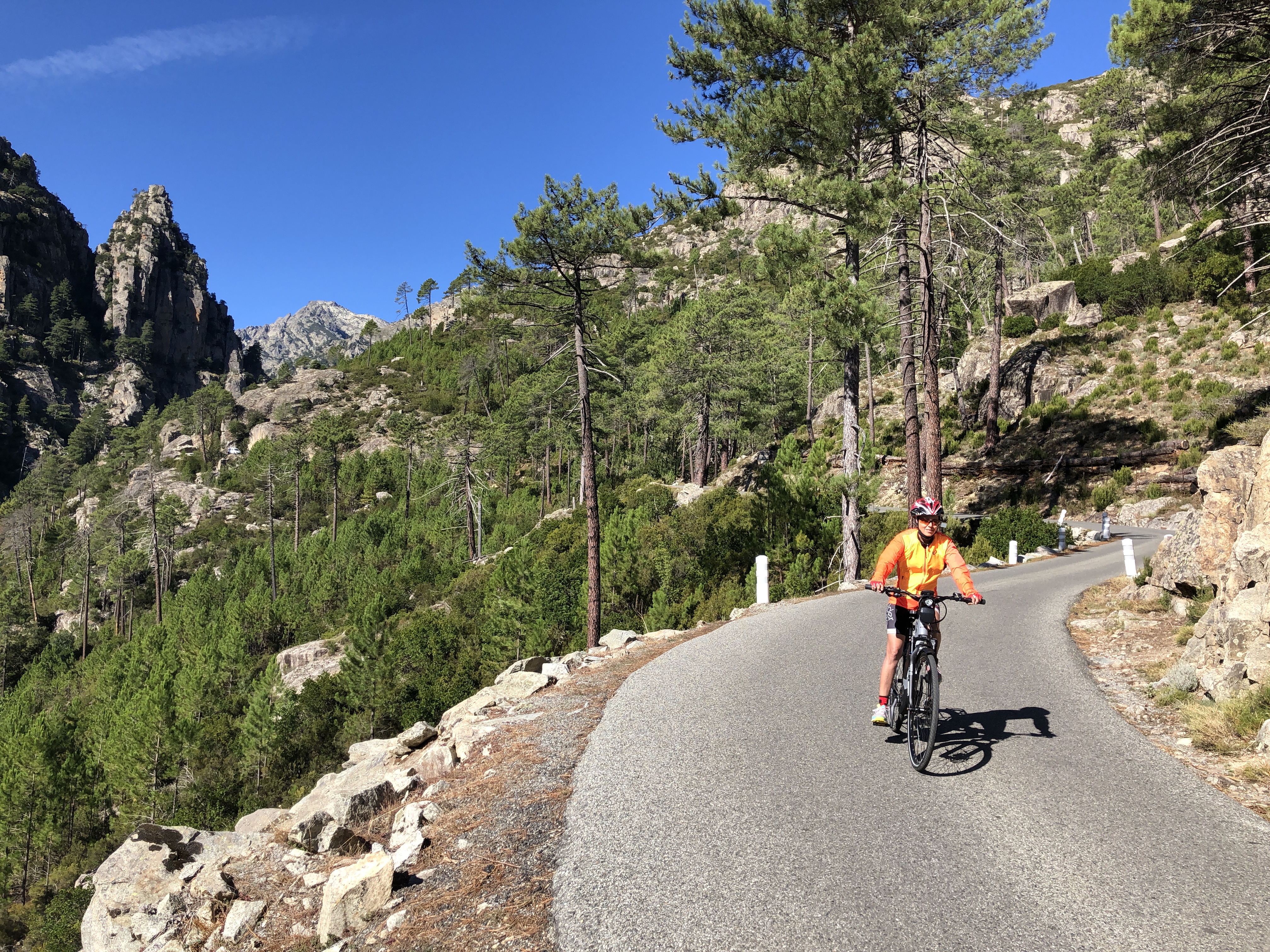
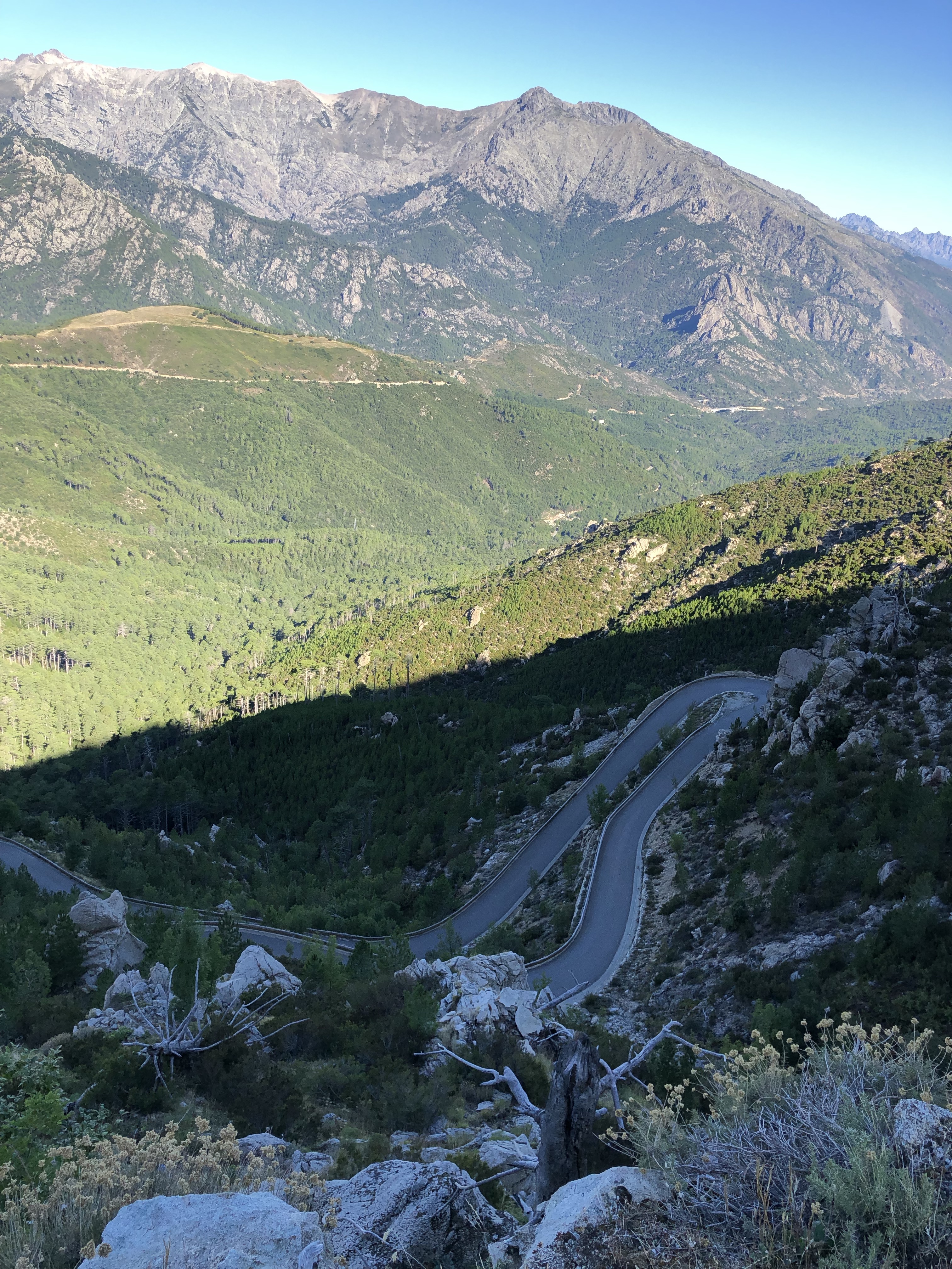
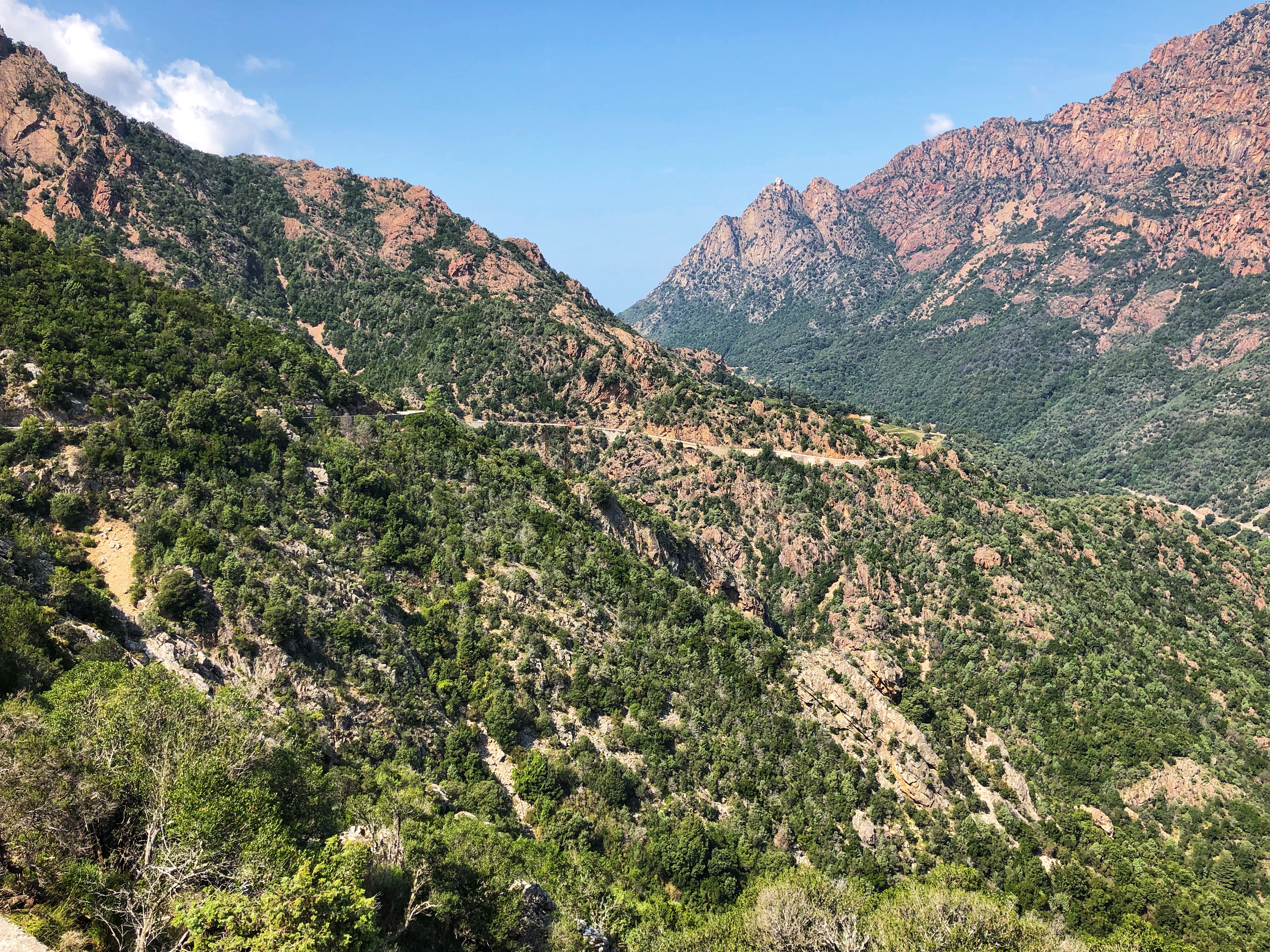 This is a long but relatively gentle climb up the D84, heading inland from the sea to the Col de Vergio. It’s about 32.5 km (20 miles) to the Col, with 1,344 meters (4,409′) of climbing. It has three distinct sections: the first 10 km is nothing special, the next 10 km were my favorite with dramatic views out onto deep valleys, rocky slopes, and spectacular cliffs, where you get to see Corsica in some of its rugged splendor. The last section from the intersection of the D84 and D70 travels through lush tall pine forests, on a wider and smoother road. Start at the intersection of the D81 and D84 in Porto and follow the D84 to the Col de Vergio. Be alert for wild pigs sleeping and eating by the sides of the road!
Extra Credit: On the way down I took a slight detour to make life more interesting and took a turn to the right signed to Ota. You drop down into the deep valley on a road that is, shall we say, less than perfect? It seems that the river at the bottom is a very popular spot based on the number of parked cars. Then climb another up through Ota, gaining another 114 meters, then follow the smooth road down from Ota to Porto.
Col de la Croix / Bocca a Croce
 This is a relatively easy ride of 22 km one-way, heading north from Porto on the D81. It’s one of those rides where you could just keep riding as far as you wanted to – even to Calvi – but I just did the short ride to the Col and back. Going out there were 357 meters of climbing and coming back I had 141 meters of climbing, for an out-and-back total of 44 km (27 miles) and 498 meters (1,634′) of climbing.
Start at the intersection of the D81 and the Porto Marina road. The first 9 km are uphill, downhill, then uphill. The remaining 13 km are basically flat and false flat. The most interesting section is the initial section through the cliffs.
Piana – Evisa Loop
 A tough loop covering a lot of varied and sometimes spectacular scenery, about 95 km (59 miles) and 1,860 meters (6,102′) of climbing. Start in Porto at the intersection of the D81 and the D84 and head south on the D81 towards Piana. You’ll be following the D81 along the coast to Sagone, the D70 uphill into the mountains, and the D84 back to Porto. So there are three roads to remember: D81, D70, D84, and every turn is a left turn. If you remember them, you know the ride 😀.
It’s about 11 km to Piana and you go through the amazing twisty, rocky section called the Calanques de Piana. It’s best to do this before the tourists get there because there can be long traffic jams with tourists parking badly and forcing traffic to alternate. And big trucks and camper vans travel this section as well which can make things even worse.
A short climb out of Piana is followed by a wonderful long descent, then rolling terrain into Cargèse, which you reach at around 29.4 km. Another 12 km of mainly flat riding leads to the pretty bay of Sagone. This whole section has a very different feel, much more peaceful than the dramatic rocky terrain you left. Ride through Sagone to a roundabout where you turn left on the D70.
Leading up to the Col de Sevi
Follow this uphill for about 21 km to the Col de Sevi (Bocca di Sevi). As you climb, just before Vico turn left at the roundabout, staying on the D70. Just after the roundabout is a brutally steep section of 13-14%, which thankfully eases, and you then have sweeping views of the valleys and mountains to your right. But you can’t relax for long as there’s another section higher up of 11-12%, then at about km 62 you can see the road slashing diagonally up the hillside, taunting, beckoning. Climb slightly over a km of 10-12% and you finally reach the Col de Sevi.
A lovely twisty downhill of about 5 km leads to a 4 km climb, through the village of Cristinacce and up to the intersection with the D84, which you reach at about km 73. Turn left and follow the D84 down through Evisa, then down through beautiful rocky terrain with amazing views, back to Porto.
Solenzara
Col de Bavella / Bocca di Bavella
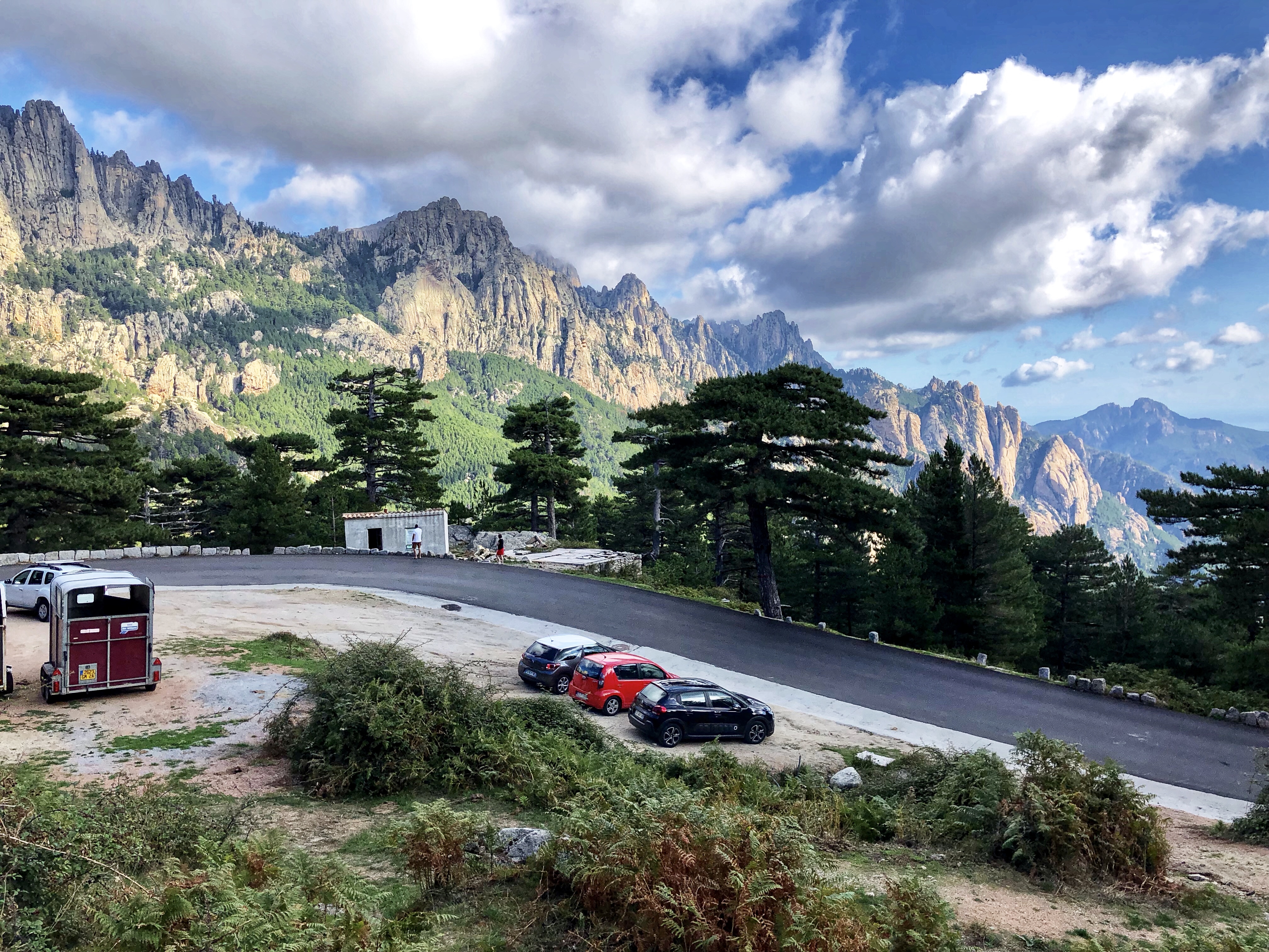 This is one of the most dramatic climbs on Corsica, with incredible views of the Aguilles de Bavella for much of the climb. The rocky ramparts you are heading towards are a cross between the Dolomites and California’s Sierra Nevada. Some of the cliffs look fantastic for rock climbing and would not be out of place in Yosemite National Park.
It’s about 29.3 km (18.2 miles) to the top, with 1,310 meters (4,298′) of climbing. If you are coming back down the same way, you’ll have another 175 meters of climbing, for a total of 1,485 meters (4,872′).
Start at the intersection of the T10 and D268, just north of Solenzara. The first 10 km are easy, with a surprising amount of downhill. At about 8.5 km you’ll pass close to the river, with its huge boulders making it a favorite swimming spot. Around 10 km you’ll pass a site that provides canyoning trips in the river, and an adventure park. Now the climb steepens and for the next 7 km there is plenty of 10-11% and one short section of 13%. You reach the Col de Larone at around 17 km.
You now have about 4.5 km of descent and false flats before the final climb to the Col de Bavella. This climb is more sustained but easier angled than the previous climb, being mostly around 9% to the Col de Bavella, which you reach in another 8 km. This part of the road is much smoother than the lower sections, which makes for a thrilling descent on the way back. You’ll probably find the top very crowded – there’s a small village with restaurants, the views are fantastic, there’s a lot of hiking from the top, and the multi-day GR-20 trail crosses here.
Extra Credit: I decided to go down to the cute little village of Zonza on the other side. Zonza looks out over a vast panorama of tree-covered hills, and at about 8.8 km from the Col de Bavella it is close enough to the Col to make it a destination for outdoor activities. The road on this side is far less steep than the east side of the Col, thank god. Strangely, as you ride back up from Zonza to the Col you will see a horse racing track on your right. Riding to Zonza and back made the whole trip 76.2 km (47.3 miles) with 1,938 meters (6,358′) of climbing.
Porto-Vecchio – Zonza Loop
 A wonderful loop with some incredible scenery and a stunning descent. There are two climbs, the longer one on the way out, and a shorter but still good climb on the way back. The loop is 83.8 kilometers (52 miles) with 1,640 meters (5,381′) of climbing.
We were staying in Solenzara so I drove down the T10 to Porto-Vecchio for this ride. I parked at a big gravel area by the roundabout where the D159 and T10 intersect. This is where the ride finishes. It starts at a roundabout a few hundred meters north on the T10 where the D368 leaves the T10, which is where these distances are measured from.
There are four roads to remember: D368, D268, D59, D159, and every turn is a left turn. If you remember them, you have the ride nailed 😀.
 Start up the D368, which is a relatively easy climb in the 4-7% range, with 8-9% occasionally thrown in. At km 16.1 and 825 meters of climbing, you reach the center of L’Ospédale, a rather nondescript village. But just above the village things get amazing. First, there are a couple of wonderful viewpoints on the left where you can look down at stunning views of Porto Vecchio and the sea and plains. Second, the climbing is soon over and you start a long section that is basically pretty flat. Third, you soon reach the Lac de L’Ospédale, a large lake with a dam at the far end, over which you cross. Fourth, this dam is where the most beautiful part of the ride starts. It’s so gorgeous, with the road twisting and weaving, flat and downhill, through fantastical rock and tree scenery, then a slight uphill to the Col d’Illarata. Now it’s mainly downhill to Zonza, which you reach after 36.8 km and 1,035 meters of climbing.
In Zonza, turn left on the D268 and follow this mainly downhill through the village of San-Gavino-di-Carbini and suffer on the terrible road through the village, then on to Levie and its terrible road. I’m fascinated by the terrible roads through towns and villages, my theory being that these roads are the responsibility of the town or village, and the residents don’t want their taxes raised to maintain the roads. Or perhaps they just keep the roads bad to slow down traffic 😀.
But enough of that. In Levie, turn left on the D59 signed to Porto-Vecchio, and pass an amazing tall and thin bell tower. Soon the road improves and you have a fast, delicious descent for 5 km, at which point the road starts climbing again. Never too steep, it climbs for 10 km and 500 meters, with a short downhill that briefly seduces you into thinking the climbing is done. Once you reach the Col de Bacino, you now have a truly wonderful 12 km descent on a lovely road with great views to the left. This was perhaps my favorite descent on Corsica.
At km 73.3 turn left on the D159 signed to Porto-Vecchio. Another 10 km of rolling terrain takes you back to your car after a wonderful day out. Just before the T10 the road splits – stay on the D159 on the left fork.
Corte
Corte is a medium-size town in the heart of the Corsican mountains. It hosts the University of Corsica with its 4,700 students, and is also a center for outdoor activities. The main street is lined with restaurants and stores, and high above the town are the Citadel, the Museum, and the Museum of Contemporary Art. Parking can be difficult.
Col de Vergio – East Side
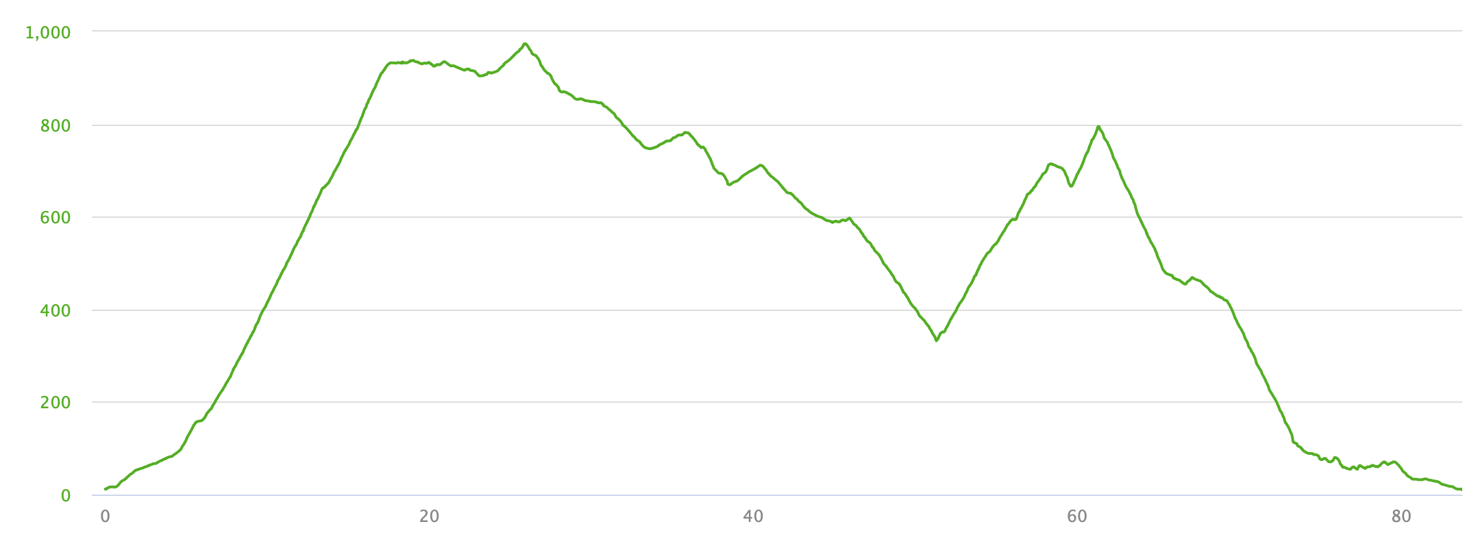
 Another wonderful ride up to the Col de Vergio, this time from the east. Some people say that going over the col and down to Porto (and possibly then up to Piana) is one of the best rides on Corsica, but that begs the question of how to get back. So I did the ride from Francardo to the Col and back. It’s not steep and has a lot of false flats, and gives a one-way ride to the Col of 44.5 km (28 miles) with 1171 meters (3,842′) of climbing. Start in Francardo, where the D84 leaves the T20.
The ride follows the D84 the whole way and can be considered in sections. The first section of 6 km is basically flat and false flat. You then reach an intersection where you turn left and now the climb starts. It’s not steep but it is spectacular as it follows a narrow road along a shelf above a deep rocky canyon – the views are even more amazing on the way back down. This canyon lasts for about 11 km and then the valley widens just above a small dam.
The next 10 km gently follow the open valley with great views of the rocky peaks up to the right. Then you start riding through trees, small trees at first, then tall pines further up. Basically the last 18 km of the ride is through the trees with occasional views of the mountains off to the right, and is the least interesting part of the ride. Turn round and ride back.
 Extra Credit: On the way down, just as you enter the deep narrow canyon below the small dam, there’s a steep road switchbacking up to the left, leading to the little village of Corsica. Since you haven’t done any steep climbing on the road to the Col de Vergio you might as well do the climb to Corsica, which has some 12 and 13%. It’s a short climb of 3 km and 224 meters of climbing to the yellow church in the village.
Col de Vergio – Both Sides
Update: I later rode the Col de Vergio from the east side over to Porto with my friend Peter. To solve the getting back part, we simply rode back 😀. To reduce the total distance we started at Ponte Castirla, at the T-junction intersection of the D84 and D18, rather than at Francardo, thus saving 12 km of uninteresting riding. Arriving in Porto, we rode down to the marina to see the dramatic bay. The ride over and back was 144 km (89.5 miles) with 2,574 meters (8,445′) of climbing. As you come down through Evisa you now see the incredibly dramatic backdrop of big rocky peaks, then lower down you see deep canyons and huge cliffs. A wonderful ride.
Restonica Gorge
 A short but stunning ride that leaves directly out of Corte on the D623. From the start of the D623 it’s only about 15 km (9.3 miles) one-way, with 886 meters (2,907′) of climbing, but the ride is incredible as you follow the narrow, twisty road through the very rocky gorge. The scenery is not as big and spectacular as some of the other rides, but is smaller and very dramatic, in part because it’s all so close up and personal, with cliffs, narrow roads, and terrifying unprotected drop-offs. The gradient varies considerably as you climb, sometimes easy, and sometimes in the 10-12%, and there’s one section starting at 10 km that is reputedly 14% for a half kilometer – I can’t verify that as my Garmin went into its Panic Mode where it showed 0% to prevent me panicking.
The road is nominally wide enough for two cars, but there are plenty of spots where only one car will fit, and even on the wider parts two cars have difficulty passing. I have mixed feelings about the ride. On the one hand it’s quite spectacular, but on the other hand the amount of traffic on the road detracts from the experience. I enjoyed it, but preferred some of the bigger, quieter rides.
Vivario – Ghisoni – Vezzani Loop
 A lovely loop, fairly short, but with a huge variety of scenery and roads, with a beautiful climb to start, a spectacular canyon in the middle, and one of my two favorite descents to finish. The whole loop is about 60.3 km (37.5 miles) with 1,348 meters (4,423′) of climbing.
Drive down the T20 from Corte for about 20 km to Vivario. As you approach the town the scenery becomes more dramatic, whetting your appetite for what is to come. I parked in the middle of Vivario.
Ride up the T20 for just over 2 km then turn left by a restaurant called Le Chalet, on the D69 signed to Ghisoni and the Col de Sorba. It’s about 7 km from here to the col and as you ride up you see the road slashing across the hillside to your left, culminating in several switchbacks to the Col. Absolutely beautiful.
From the Col it’s about 10 km down to Ghisoni, which you reach at 19.2 km. Turn left on the D344, signed to Ghisonaccia. Follow the road down beside a spectacular canyon for 11.6 km. In different places you’ll see wonderfully water sculpted rocks and enormous boulders in the riverbed. One of the more dramatic parts is the Défilé de l’Inzecca, about 8 km from where you turned left.
Towards the end of this section you go through a tunnel which is reasonably well lit. About 2 km after the tunnel, turn left on the D344a, signed to Vezzani. The D344a is a small, quiet road of about 3 km that leads up to the Col de Cardo then descends to the D343. The road surface on the last 200 meters to the Col and down to the D343 is rather rough.
Turn left on the D343 and climb gently up for about 14 km to Vezzani. About 2 km after Vezzani you reach the Col d’Erbajo and a gentle downhill and flattish section leads to the Col de Morello and spectacular views. A beautiful descent leads to the little village of Muracciole then another kilometer of downhill leads to the final easy 2.5 km ascent back to Vivario.
Corte Eyeglass Loops
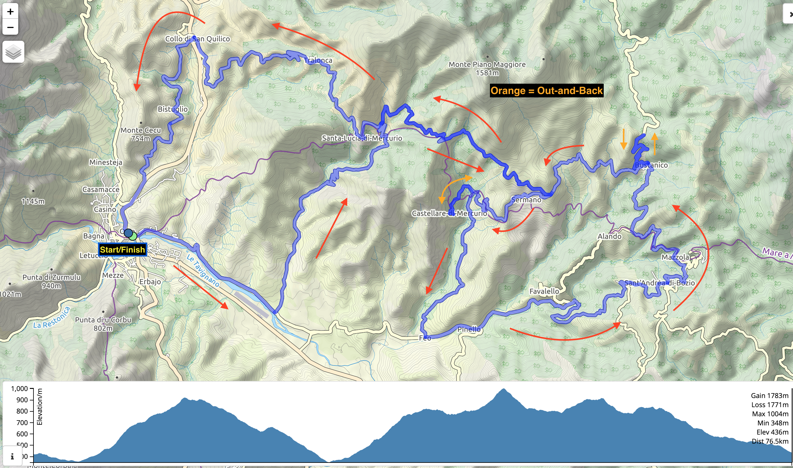 This is a fun set of climbs, descents, and rolling terrain, leaving directly from Corte and wandering around the hills to the north and east, with a couple of Extra Credit out-and-backs. The whole ride is about 76.5 km (47.5 miles) with 1,540 meters (5,052′) of climbing, although I felt more tired by the end that those numbers warrant 😀.
Start at the intersection of the T20 and the D39. Head east along the D39 for just over 4 km. Turn left on the D341 and climb up for about 7.5 km to the intersection with the D41 just east of Santa-Lucia-di-Mercurio. Most of this pleasant climb is in the 5-8% range with a few ramps of 9-11%
 Turn right on the D41 and climb then descend for about 7 km until the D41 doubles back on itself down to the right, heading to Sermano and Castellare-di-Mercurio. Follow the D41 down, and for the extra credit, take the D241 up to the high point in Castellare, finishing with a brief ramp of 20%. Back down to the D41 and continue down, never very steep but wonderfully sinous.
At the intersection with the D39 turn left and continue for about 4 km to where the road splits, with the D339 continuing straight. Follow the D339 as it wanders around, relentlessly twisting and turning, often with a fantastically smooth road surface, until you finally reach Bustanico about 11.5 km after the D339 intersection. Even from a distance you can see the impressive switchbacks about Bustanico.
Here is your second extra credit, with a steep climb up those switchbacks, up the D39 for 2.2 km, with gradients mainly in the 9-10%. Back down again, then turn right on the D441 and continue on this and the D41 for about 20 km, as it rolls up and down through Santa-Lucia-di-Mercurio to Tralonca and then wonderfully down to the T20. Just before you reach the T20 the road splits. Take the right hand branch which crosses the T20 just above the tunnel. At the junction turn left on the T203 and follow this until it joins the T20 and continue down this to the intersection with the D39.
Bastia
Bastia is a larger and busier town at the base of the finger at the top of Corsica. It’s the start of one of the best rides on the island. We didn’t stay in Bastia but drove up from Corte to do the ride.
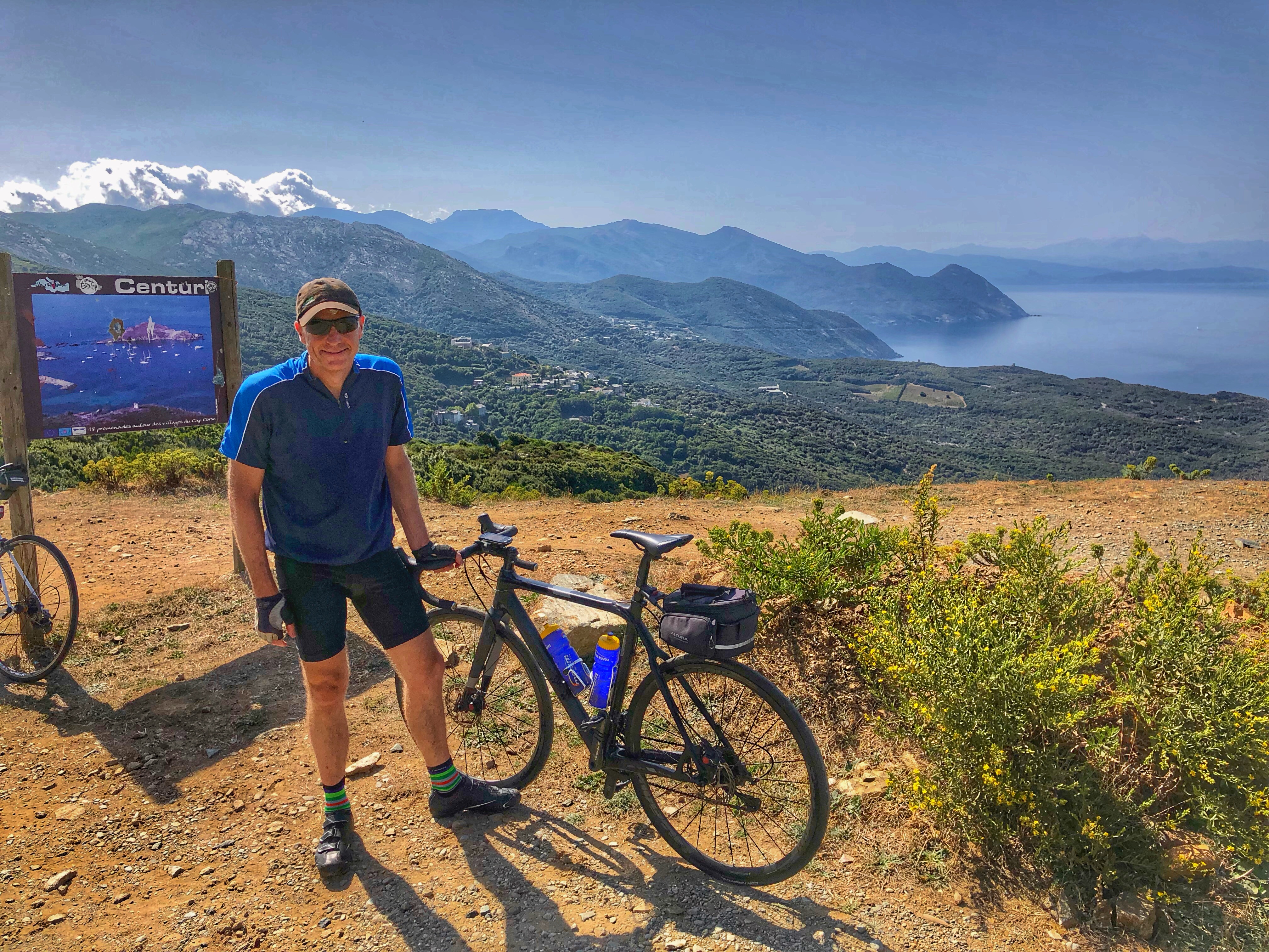
Cap Corse Loop
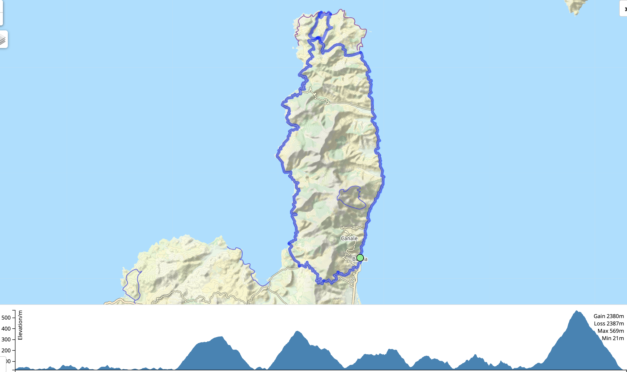 A fantastic ride, one of the best on Corsica and well worth doing. We saw quite a few cyclists doing the loop, including a group made up of some people on regular road bikes and some on e-bikes. The climbing is never steep except on the final big hill before the finish. The ride is about 137 km (85 miles) with 2,036 meters (6,680′) of climbing. These numbers include the extra loop at the tip of the peninsula. It’s best to do the loop counter-clockwise so you have the best views of the sea all the way.
Start and finish in Bastia. Parking is difficult so you may to search around. We found a small free parking lot called Parking de Toga. Apart from Bastia the route finding is incredibly easy as you basically just follow the D80 and D81.
Ride easily north on the D80 for about 35 km to the cute little port of Macinaggio. The D80 heads inland here and climbs gently for about 10 km to the little village of Botticella.
At this point you have a choice: you can continue on the D80, or you can do as we did, and turn right on the D253 and ride a very pretty 16 km loop with lovely views, down to the sea and the little villages of Barcaggio and Tollare then back up. You can do the loop either way: the right hand branch to Barcaggio is longer and on a better road and this is the way we went down. Ride the short distance from one village to the other then back up the other road.
 Back on the D80 continue climbing for about 1.5 km to an overlook with a beautiful view of the west coast and the bays and peninsulas you will be riding round. The next 50 kilometers along this spectacular coastline are what makes this such an incredible ride, starting with a 10 km descent, then continuing with 40 km of rolling road.
Finally, the D80 turns inland and in about 4 km you reach a roundabout where the D80 meets the D81. Turn left and follow the D81 up through Patrimonio. From the roundabout you have a beautiful 8 km climb to just past the Col de Teghime, before you finally descend into Bastia. The climb is mostly fairly easy but as you approach the top the gradient increases dramatically, being mainly in the 9-11% range.
As you descend towards Bastia the road splits – take the left hand branch signed to Centre Ville – this is the D81. Continue down this past various intersections and roundabouts, following signs for the Port. Once back on the D80 by the port, ride back to wherever you left your car.
Links and Other Clicks
Corsica Cyclist is a great site for information about cycling in Corsica. I got the ideas for many of the rides we did from this site.
