
Update, March 2025: I rode the loop again on 3/1/25, clockwise this time. I describe this alternative at the bottom of the page.
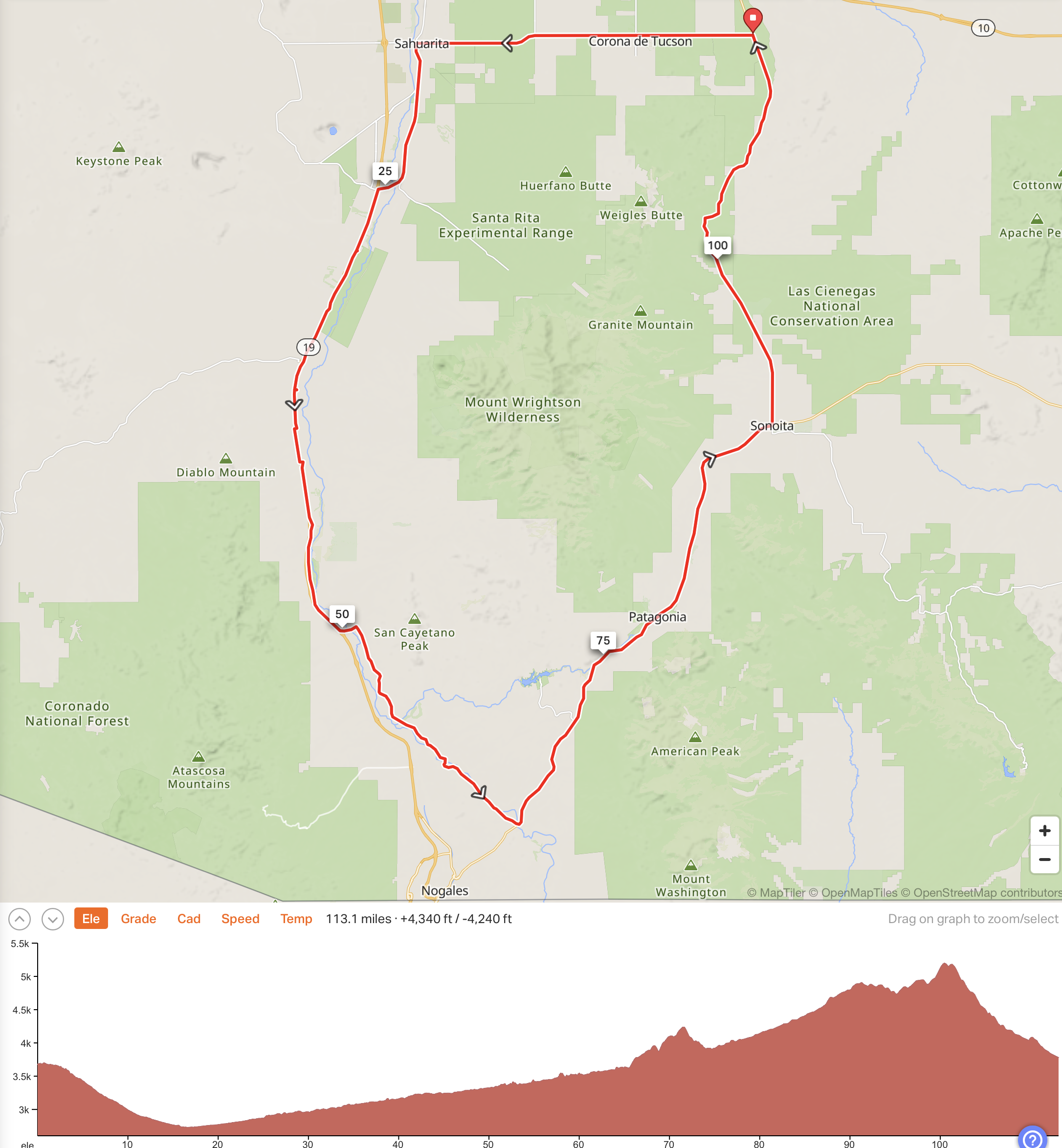
This loop is a the shortest road loop around Mt Wrightson and the Santa Rita Mountains. It’s a mainly enjoyable loop of about 113 miles with about 4,100 feet of climbing. I rode it counter-clockwise, on 4/4/24.
Click on the map above, or click here to see the ride on Ride with GPS. You can then export the GPX file under More, Export as File.
I had originally thought of starting in Sahuarita and heading east towards Hwy 83 but decided that riding 17 miles east into the early morning sun on a fairly busy road was not a good idea. So I parked in the big dirt parking area at the intersection of Hwy 83 and Sahuarita Rd, and rode west to Sahuarita, with the sun behind me.
It’s mainly downhill to Sahuarita, although it’s not a great deal of fun with commuter traffic on the road. Fortunately after about 17 miles you turn left onto Nogales Hwy and follow this for two miles then turn left at the lights onto Continental Road. Follow this for about 6 miles, past various signs pointing to Madera Canyon. Immediately before the I-19 freeway, turn left on the the frontage road.
Follow the frontage road south past Amado to a bit before Mile 39 where you have to turn right and cross I-19 (if you try to continue straight you’ll see a No Outlet sign.
Once across the bridge turn left and ride south on I-19 for just under a mile and exit at Chavez Siding Road. Again, cross I-19 back to the frontage road on the east side. (This whole exercise is because there are no frontage roads between these two I-19 exits due to the Border Control post on I-19.)

Follow the frontage road south past Tubac and Tumacacori. The photo above was taken just before Tumacacori.
At Mile 50 you reach what is basically a T-junction at Palo Parado Road. Turn left and follow this for a few hundred yards to another T-junction at Pendleton Drive. Turn right and follow Pendleton Drive for about 10 miles. Some of Pendleton Drive doesn’t have much of a shoulder but there is a bike path to the right if you are uncomfortable on the road.
Pendleton Drive was the most fun part of the ride for me. It’s a bit of a roller coaster, with pretty views and a road that twists and turns and rolls.
At about Mile 60, by the fire station, turn right on Ruby Road, then in a few hundred yards turn left on Via Frontera. Turn left again at the t-junction on South River Road and follow this for about 5 miles to the intersection with Hwy 82. Turn left on Hwy 82 and follow this for about 13 miles to Patagonia, which you reach at about Mile 78. On the way you’ll pass the tiny Nogales International Airport, and you’ll also climb some decent hills.
In Patagonia you can take branch right and pass various stores and restaurants, or keep going on Hwy 82. Continue for another 13 miles to Sonoita, where you turn left on Hwy 83, signed to I-10.
The road now rolls seriously for about 10 miles with some good uphills, then finally, thankfully, you do a long 12 mile descent back to the start, at Hwy 83 and Sahuarita Road.
Refueling Points
Here are some places you can buy food and drink if you need to refuel.
- Just before Tubac, at about Mile 43, just before Bridge Road, there’s a gas station on the left.
- As you are leaving Tubac, shortly after Plaza Rd there is another turnoff on the left which brings you to Tubac Market.
- In Patagonia, around Mile 78, there are restaurants on the right in Patagonia. As you leave Patagonia, the Patagonia Market is on the left.
- In Sonoita, around Mile 91, on the NE corner of Hwy 82 and Hwy 83 there is Dollar General.
Riding the loop Clockwise
On 3/1/25 I rode the loop clockwise, starting at the same point at the big dirt parking area at the intersection of Hwy 83 and Sahuarita Road. This time my bike computer showed the loop having about 4,500 feet of climbing.
The disadvantage of riding clockwise is that the climbing is concentrated at the start and the end. The advantage of riding clockwise is that there’s a lot of gradual downhill between Sonoita and Sahuarita. I had thought I would prefer the counter-clockwise route, but ended up preferring the clockwise ride because of all the gradual downhill.
So, follow Hwy 83 as it climbs and rolls uphill to Sonoita through pretty country. There’s no real shoulder but when I rode it on early on a Sunday, there was very little traffic. From Sonoita it’s mainly a lovely gradual downhill through Patagonia, along the pretty River Road, along lovely Pendleton Drive, and along the frontage road through Tubac to Green Valley and Sahuarita, with a slight detour on I-19 to go through the Border Control.
Once you get to Sahuarita Road, it’s now about 17 miles of false flat uphill back to the car. Perhaps not exactly what you want after riding almost 100 miles, but a small price to pay for all the lovely riding up to this point. And you are now riding away from the sun with a good cycling shoulder, which makes it feel very safe.
Here’s the route on Ride with GPS, from where you can download the GPX file (under More, Export as File).
