
Tired and happy at the top of the final climb, Kitt Peak
The three great road-bike climbs in the Tucson area are Mount Graham, Mount Lemmon, and Kitt Peak. This page is about doing all three in a day, on May 24, 2014.
Statistics
I didn’t have a bike computer when I did this so I’m taking the distances and elevations from John Summerson’s book The Complete Guide to Climbing (by Bike).
I also did the rides as described in his book. So the Mount Graham climb went up to the somewhat arbitrary point where the real climbing ends, and Mount Lemmon started at Mile 0 (Mt Lemmon Short Road).
The distances and elevations Summerson gives for the one-way ride to the top are:
| Climb | Miles One Way | Feet Climbed |
| Mount Graham | 18.5 | 5,572 |
| Mount Lemmon | 28.5 | 6,222 |
| Kitt Peak | 12.4 | 3,579 |
Doubling the distance since you have to ride down, and adding the distances and elevations, the total amount of riding is about 119 miles, and 15,373 feet of climbing. However I suspect the elevation gain is more like 16,000 feet as there are about 600 feet of climbing on the way down from Mount Lemmon.
The distance and feet climbed make the ride somewhat comparable with Colorado’s Triple Bypass (120 miles and 10,990 feet of climbing) and California’s Markleeville Death Ride (129 miles and 15,000 feet of climbing). The difference is that the Tucson Trifecta requires several hours of driving in between climbs which makes the day considerably longer.
I’m not the fastest cyclist and I’m listing my car-to-car times so that readers can compare how long I took on the different climbs with their own time on any of the climbs, and from that extrapolate how long they might take for the whole thing.
| Climb | Time (round trip) |
| Mount Graham | 3 hours 35 minutes |
| Mount Lemmon | 4 hours 42 minutes |
| Kitt Peak | 2 hours 10 minutes |

Bad weather at Windy Point on Mount Lemmon
The whole day from car-to-car took me exactly 14 hours, to the minute. I started Mt Graham at 3:50 am and got back down from Kitt Peak at 5:50 pm. The weather conditions were pretty much ideal – cool temperatures and quite a bit of cloud cover on Mt Lemmon. The only bad patch was seven miles of rain on Mt Lemmon between miles 8 and 15.
The Climbs
Mount Graham
I drove up to Safford (East on I-10 to exit 352 then head north on Highway 191 to Safford) and stayed at the Days Inn.
I had no idea how long the whole day would take so decided to play it safe and start riding very early. From the main intersection in Safford, where Highways 191 and 70 intersect, drive south on 191 for 7.3 miles to Swift Trail Junction (just south of mile marker 114). Turn right onto Highway 366, which is signed to Mt Graham. Park in the dirt by the side of the road somewhere near the intersection.

Looking down the Mt Graham Road
Follow the road up, initially in a straight line, but after a few miles you reach the turns and switchbacks. The final few miles before the shoulder are in the trees with many tight switchbacks. After you reach the shoulder (near mile marker 131) the road goes behind the mountain and the road surface improves. There are great views down into the valley below. Eventually, about half a mile past mile marker 132 the road turns slightly right and goes downhill and the main climbing is over. There is a big parking area on the left and a trailhead sign for the Shake Trail. This is where the listed climb finishes (the road rolls along for a few miles more but with no real climbing.) As you ride back down in the early morning you have the sun in your eyes, which makes it difficult to see the road and switchbacks well.
Mount Lemmon
121 miles of driving. Drive south on 191 from Swift Trail Junction to I-10 and follow this west to the Houghton Road exit. Follow Houghton Road north until it intersects the Catalina Highway. Turn right and park at Mile 0. This mile marker seems to have disappeared but it’s where the Mount Lemmon Short Road heads off to the right. You can park in the dirt just before the Short Road, or park in a paved pull-out area just before the first switchback and ride back down to the Short Road to start the climb.

Looking down from Windy Point
Follow the road for almost 25 miles, including a two mile downhill section. Just as the road descends into Summerhaven turn right up Ski Run Road and follow this for just over 3 miles to the big dirt parking lot on the left by the Sky Center gate, which is usually closed. Turn round and ride back down, with bonus climbs out of Summerhaven and the two mile climb that you previously descended.
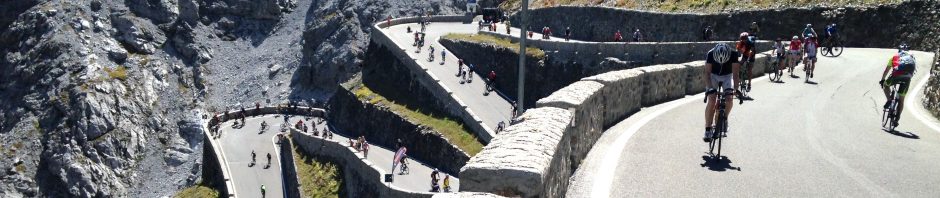
Kitt Peak
57 miles of driving. Drive to Highway 86, the Ajo Highway. Follow this west to the turnoff for Kitt Peak. Turn left and park in the large dirt parking area on the right.

Kitt Peak road with Baboquivari in the background
From here climb the road as it slashes across the hillside to the right before finally going round the back of the mountain and continuing another 3 miles to the Visitor Center. There is a gate near the bottom of the road that closes at 4 pm but it’s only closed on one side so there is no problem riding up. Ride back down to the car to complete an amazing day.
Notes
Summerson’s second edition book says that Mt Graham is the 20th hardest climb in the country while Mt Lemmon ranks 42. I think that Lemmon is harder, mainly because of its much greater length. Summerson seems to give a greater weight to steepness in his rankings than I would, whereas I would give length a greater weight. In the first edition of the book Kitt Peak ranked number 100, but it has disappeared from the top 100 in the second edition.

Also within reach of Safford in the ‘tough and rewarding day’ category are the switchbacks on the Coronado Trail (US 191) between Clifton and Alpine – great climbs for the road cyclist, on a route with very little traffic.
http://www.strava.com/activities/152949917
This can be combined into a 210-mile AZ/NM loop via Mule Creek, Glenwood and Luna:
http://ridewithgps.com/routes/551895
Services are limited on both of these routes.
LikeLike
That’s a heckuva ride!
I would recommend Madera Canyon, Mount Hopikins and the ride from Amado to Arivaca as three great Green Valley, Arizona climbs. Check them out at bikeaz.org/bikegreenvalley.
I rented a bike from these guys and did Graham as well. Unforgetable.
http://tucsonbikerentals.org/best-tucson-roadbike-rides/mount-graham-hill-climb-safford/
LikeLike
Thanks Thomas. I’ve written about the Mt Hopkins climb at: http://www.contributingtotheproblem.com/?page_id=351
I didn’t write about Madera Canyon as I decided not to describe rides that were covered in the book “A Guide To The Best Bike Rides In Tucson Arizona “. Maybe I should revisit that decision.
Thanks for the suggestion about the Arivaca ride – it looks good.
LikeLike
Hi Alec,
It looks like you enjoy the same types of rides I do. Your write-ups are great, and thanks for them. I’m doing the Mount Lemmon Gravel Grinder in September, and I wanted your point of view on something. I have a Trek Boone with TRP v-brakes, a 40mm tire on the front and 35mm on the back (clearance issue), set up tubeless with a 40X36 low gear. As described, it’s 18 pounds–a sweet bike, and I love it. I also have a Trek Farley fat bike, also set up tubeless, and it weighs 31 pounds. It actually rolls surprisingly well. I think the Boone would be great on the way up Lemmon CR, but then the course turns around and heads back towards Redington Rd.–a super long downhill and much of it is very rough. I’m worried that the Boone will beat me up pretty bad, and, despite the weight and rolling resistance penalty, that the Farley might be a better choice. Unfortunately, I don’t own a regular 29″ mtb, which is probably the best bike for the ride, given that it also includes 13 miles of pavement. Looking at your pics of the upper control road, it looks pretty rough. Based on your experience, which bike would you choose? I’d really appreciate your opinion. Also, I plan on riding Mount Hopkins this fall, and I’m really looking forward to it. I really enjoyed your write-up.
LikeLike
Hi Charlie, I’m no expert on such matters, but here goes. Are you doing the 40, 50, or 60 miles? The Control Road above the 4450 (Black Hills Mine Rd) turnaround is much rougher and steeper so I’d be inclined to go with the Farley if you are doing the 50 or 60. But if the 40, I’d go with the Boone. Yes, the fat bike will be more comfortable, but if you want fast, the Boone will be better on the uphill, the flats, and the pavement. Going down Black Hills Mine Road will be brutal but maybe you can take more weight on your legs? What I don’t know is how comfortable you are going fast downhill on rough dirt on a cyclocross bike. That might determine the decision!
LikeLike
Thank you, Alec. I truly appreciate your opinion on this, as you have ridden this road before and I haven’t. I’m doing the 60 mile route. If I were riding up from Oracle to the Control Road and then just riding the road down to Le Buzz, I think I’d take the Boone, no problem. That long descent after the turn around at the top concerns me a bit on the Boone. I’m a good descender, but that’s a long time to be bouncing all over the place–maybe an hour. That might just suck all the fun out of it for me. I will try to do a recon ride beforehand and test out the Boone, but I’m leaning towards the Farley on the day of the event. Thanks again for your input!
LikeLike