
Originally this page gave very brief descriptions of cycling climbs I did, or Tanya and I did on the tandem, in July and August, 2014. We took a road trip to Utah, then Wyoming, back to Utah, finishing in California. All the climbs were from the second edition of John Summerson’s book, The Complete Guide to Climbing (by Bike), and if the climb is in Summerson’s top 100 climbs, I’ve shown Summerson’s ranking. For example, #14 means Summerson rates the climb as the 14th hardest in the U.S. I also show Summerson’s ratings of the climbs, so S-1 means Category 1, and S-HC means Hors Category.
But we have been back to California since 2014 so I’ve added information to many of the climbs, and I’ve added additional rides. For a few climbs that I haven’t repeated since 2014, I only give my impressions of the climbs. So if you want to know where these few climbs start, buy Summerson’s book. He also has a book specific to California, which is probably a better book to get if you are interested only in California.
If you are interested in cycling in California, a wonderful web site is Best Rides, which has great descriptions of what the author thinks are the best rides in California and Oregon.
Now, onto business. Here are links to the various sections in this long page, so you don’t have to do too much scrolling (some of the sections have now been moved out to their own web page).
- Eastern Sierra
Mt Shasta City
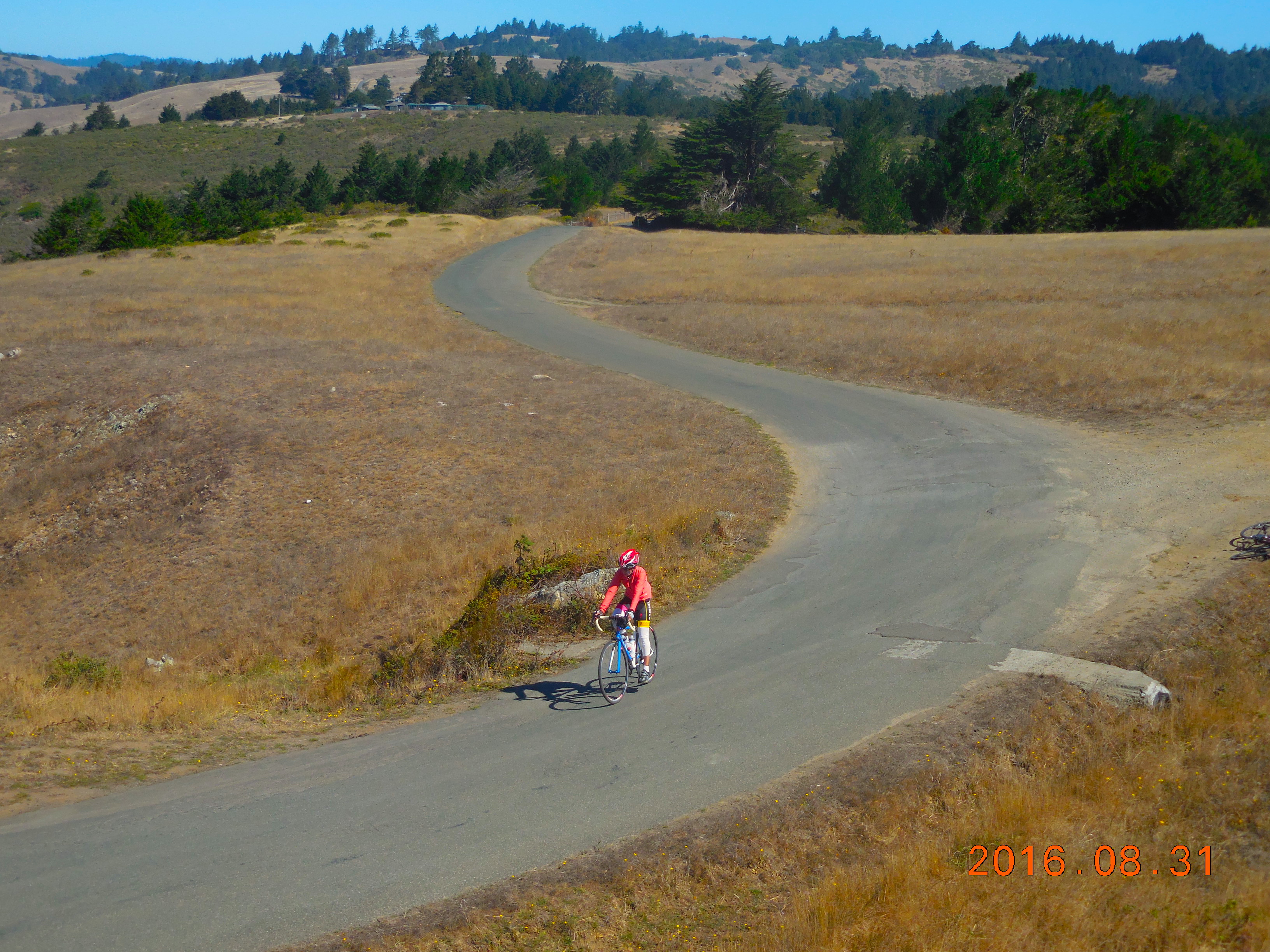
Sonoma County
Bay Area
San Luis Obispo County
Santa Barbara Area
Malibu / Santa Monica Mountains
San Gabriel Mountains
Los Angeles
Visalia
San Diego
Death Valley
Other Areas
Eastern Sierra

After our main road trip in 2016 we went back to Tucson for a week then Tanya left to visit family in India. I decided to return to California as I wanted to do some of the big climbs in the Eastern Sierra. Rather than include them in this page, I’ve written a separate page about the Eastern Sierra climbs.
Mt Shasta City
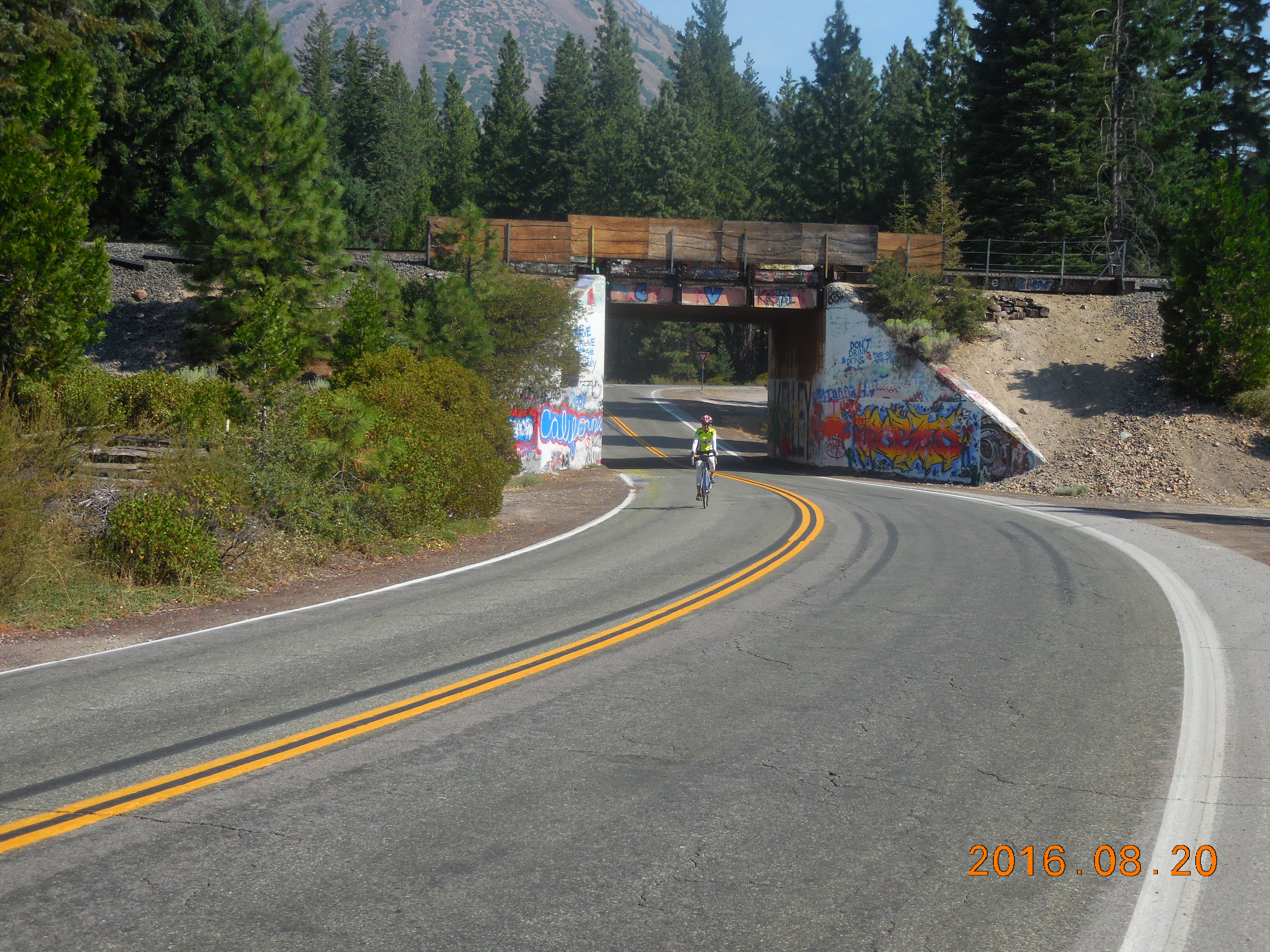
Mt Shasta City is a small town on I-5 just south of the Oregon border, nestled under Mt Shasta. The main ride here is to climb the Everitt Memorial Highway up the flanks of Mt Shasta. There are other rides in the area: Summerson lists two more hard climbs, there is a good 8 mile climb to Castle Lake, and Cycle Siskiyou lists several rides and has maps of each. You can also pick up a map of the Siskiyou County Bike Routes in the Fifth Season store in Mt Shasta City.
Mt Shasta (#67, S-1)
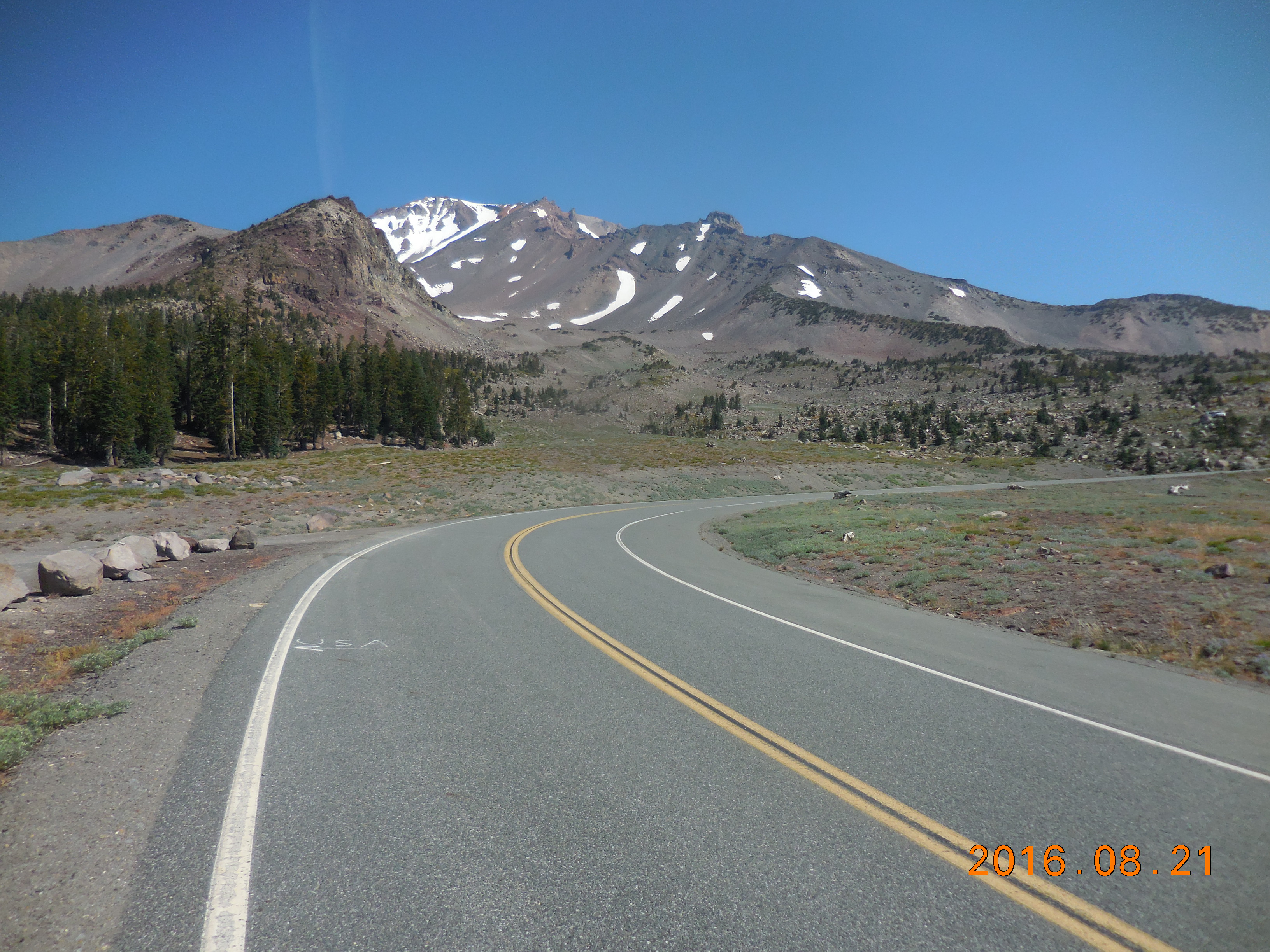 This is the big climb in the area, finishing under the rocky, barren slopes of Mt Shasta. It’s about 14.4 miles long with 4,100 feet of climbing. It has a reasonably consistent gradient on a smooth road with a good shoulder, but it’s never very steep. The last couple of miles give you great views of Mt Shasta.
You can start anywhere in Mt Shasta City, and I chose to start at the intersection of Lake Street and Mt Shasta Blvd. Ride NE on Lake St then bear left on N Washington Dr. Continue north on this as it becomes Everitt Memorial Highway. Follow this to the end. At mile 14 the composition and color of the road changes and it becomes very cracked for the last 0.4 miles.
Old Stage Road
 This is a lovely 26 mile out-and-back along a smooth road with some good rollers and very light traffic.
Start at the intersection of Lake Street and Mt Shasta Blvd.
Ride down Lake St, across the Interstate, then it becomes Hatchery Ln. At the T-junction, turn right on Old Stage Rd. At the T-junction at mile 3.8 turn left following Old Stage Road. At the 4-way stop at 6.0 miles, continue straight. At the T-junction at 13.3 miles turn around and ride back.
Options:
- From the T-junction at the end, turn left on Old 99 Hwy, ride 0.5 miles, then turn left on Stewart Springs Road, and ride up this gentle climb for 4 miles to the resort. After the lovely smooth Old Stage Road, this road feels very rough.
- Ride back along Old Stage Road for about 3 miles to College Ave on the left. Turn left and ride College Ave into Weed then ride the Hoy / Edgewood loop. We were told about this by some cyclists we met – they said it was very pretty but the road is not so good in places.
- On the way back along Old Stage Road, simply explore the many roads that head off to the sides.
Sonoma County
The cycling in Sonoma Country is well known for its short steep hills, and its crappy roads. Not all roads are bad – in fact some of them are super-smooth (and usually have more traffic), but the less-traveled roads are often rough and pot-holed. The riding is okay but not my favorite. The Santa Rosa Bike Club has a web page showing “10 great rides“. There’s also a very good Sonoma County Bike Map that you can order online or buy in bike stores.
King Ridge Lollipop
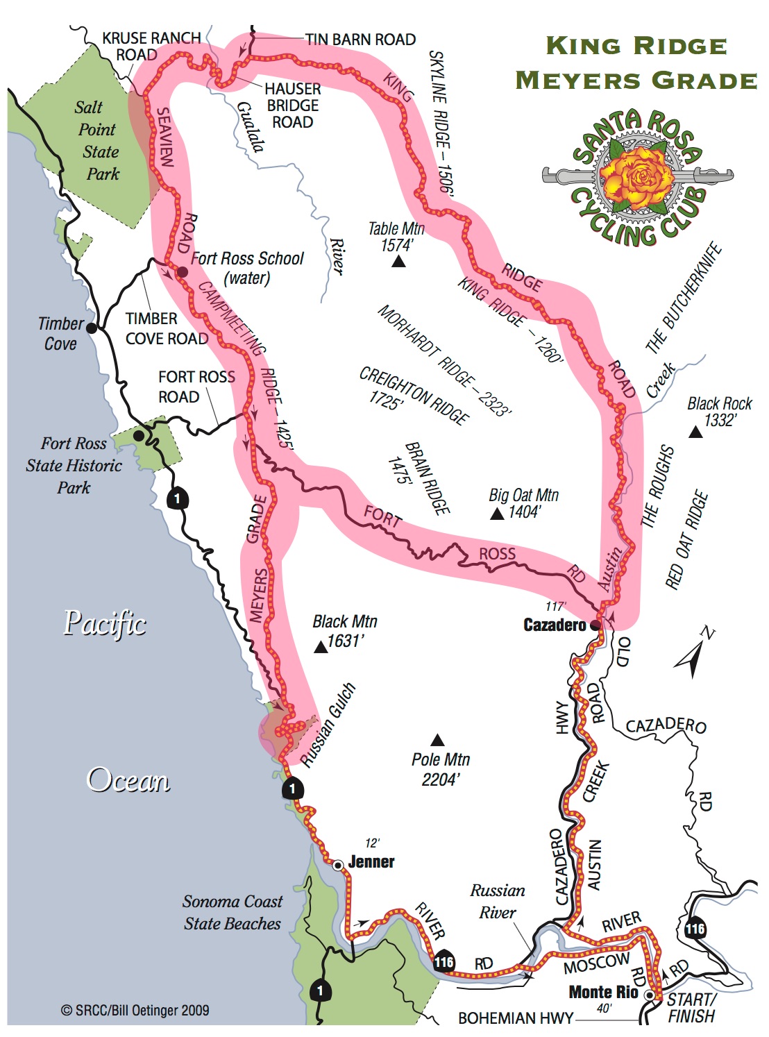 King Ridge is the only reason I can see to come to this area. It has plenty of rough and potholed road, but it’s a great ride: tough and varied, with lots of very steep climbing and wonderful views on the top of the ridge. It’s a famous ride: it’s part of Levi Leipheimer’s Gran Fondo and the Amgen Tour of California has raced this road – I can’t imagine going full speed down some of these hills.
I don’t particularly like riding through trees, and I especially don’t like riding through trees with dappled sunlight on bad roads. There’s plenty of that on this ride, but for this one ride, it adds to the adventure.
 The classic ride starts in Monte Rio and is 55 miles long. Jay Rawlins includes a variant in his “Best of the Best.”
I chose to ride it in yet another way (the even better way), with more climbing and less flattish riding. It includes all the climbing on the classic ride, and adds the incredibly steep Meyers Grade Road, and Fort Ross Road.
My variant is 49 miles with 7,320 feet of climbing. I saw almost no traffic on most of the loop. Here’s a useful map.
Park on Hwy 1 about 3 miles north of “downtown” Jenner, at the bridge by the turnoff to Russian Gulch beach, just below the big switchbacks. (I parked just before the bridge but there is more parking after the bridge.) Here are the basic ride directions:
- Ride up the beautiful switchbacks
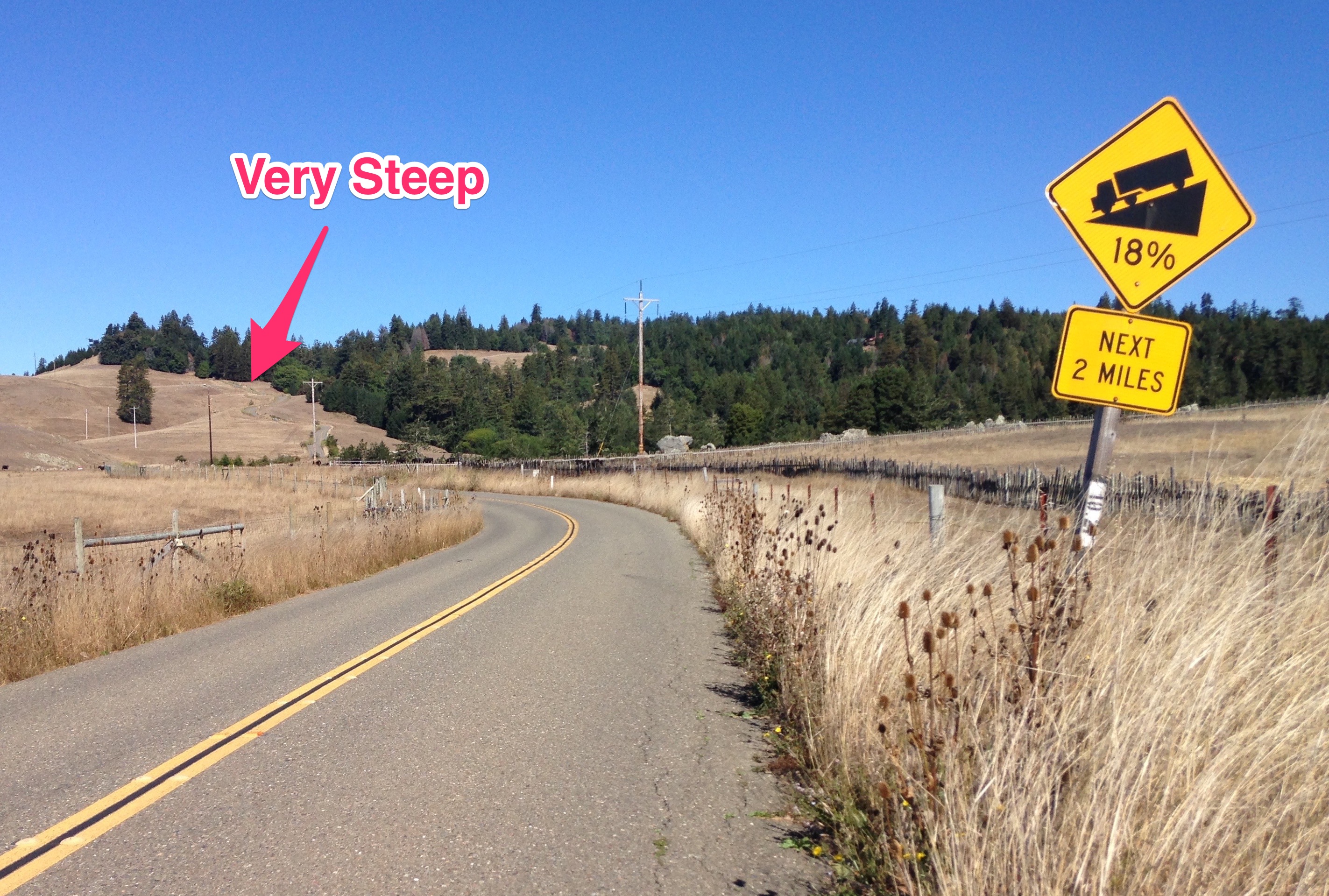
- At the end of the climbing, at about mile 1.83, turn right onto Meyers Grade Road. This road has some super steep sections where my Garmin showed 20%.
- At mile 6.65 turn right onto Fort Ross Road, following the sign for Cazadero
- At mile 15.67 you reach Cazadero. Turn very, very sharp left onto King Ridge Road
- Follow King Ridge Road easily at first, then more steeply. The next 16 miles vary a lot, with some steep climbing, some rolling riding, trees, no trees, and beautiful views when you are on the ridge out of the trees. The ridge section is what makes the ride great.
- At mile 31.7 turn left following the sign for Hauser Bridge. Descend down to the bridge on a better road than some you’ve been on. The bridge is a one lane, metal surfaced bridge.
- Climb steeply from the bridge then at mile 38.5 you reach an intersection. Continue straight on Seaview Road, following the sign for Cazadero and Jenner.
- Eventually you’ll descend the very steep section on Meyers Grade Road and reach Hwy 1 at 47.14 miles.
- Turn left and descend the wonderful big switchbacks back to your car at 49 miles.
Coleman Road Loop
 Starting in Occidental, this loop is 24.7 miles with 3,300 feet of climbing. As with all the riding in this area, the road quality varies considerably, although is never really bad. And the hills, while not long, can be viciously steep. The hardest part of this loop is climbing Joy Road. It’s a wonderful rolling ride with great views and great climbs.
[This ride is a shorter version of the Sonoma Coast loop, and with a slightly different finish. Here’s a useful map. You can also do Coleman Valley Road as an out-and-back. We also did the start of the Sonoma Coast Loop through Monte Rio and down the Russian River then came back up Coleman Valley Road, which gives a great 770 foot climb in 1.5 miles as you leave Hwy 1.]
Start in Occidental and ride west on Coleman Valley Road, with a steep climb out of town. The road rolls for several miles before a 1.5 mile, 770 foot descent drops you down to the coast and Hwy 1 at about 10 miles. Turn left and follow Hwy 1 for about 2 miles. A few hundred yards after the Bodega Bay city limit sign turn left onto Bay Hill Road. Just under 4 miles later, after some good climbing and descending, you rejoin Hwy 1. Turn left and follow this with a reasonable shoulder for 1 mile then turn left at mile 16.85, following signs for Bodega and Sebastapol.
You are now on a beautiful road with a lovely shoulder, so follow this through Bodega. A short distance after Bodega, at about mile 18.25, turn left on Joy Road. Climb this with several very steep sections up to Coleman Valley Road. The upper part of Joy Road is an interesting residential area in a redwood forest. Descend the other side of Joy Road to the Stop sign. Continue straight onto Coleman Valley Road and follow this as it climbs then makes a big descent into Occidental.
(The Sonoma Coast ride turns right on Bittner Road near the top of Joy Road, which reduces the amount of climbing a bit.)
Bay Area
Mt Diablo (S-1)
 Mt Diablo is a beautiful climb from either the north or the south. From the south it’s about 11.2 miles and 3,320 feet of climbing. The road twists and turns and the views are wonderful. The northern and southern routes join about 4.5 miles from the top. The final two hundred yards is far and away the steepest section on the climb, reaching a 17% gradient.
We’d previously ridden both sides of Mt Diablo but on this trip we rode it from the south. The climb starts at the intersection of Blackhawk Road and Mt Diablo Scenic Blvd. We parked a short way up Blackhawk Road on Diablo Creek Place. This is another of Jay Rawlins’ “Best of the Best” rides.
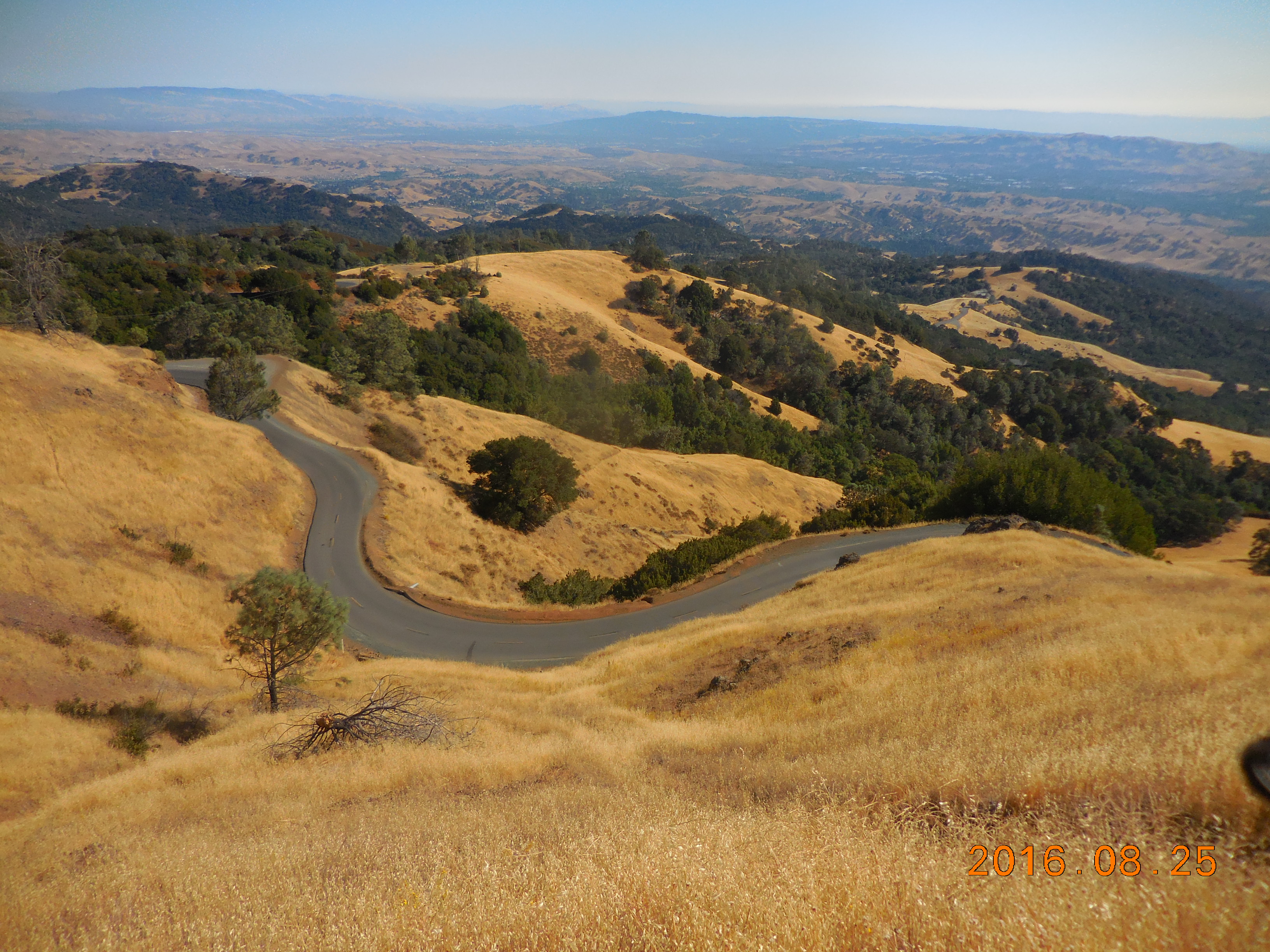
Mt Hamilton (S-1)
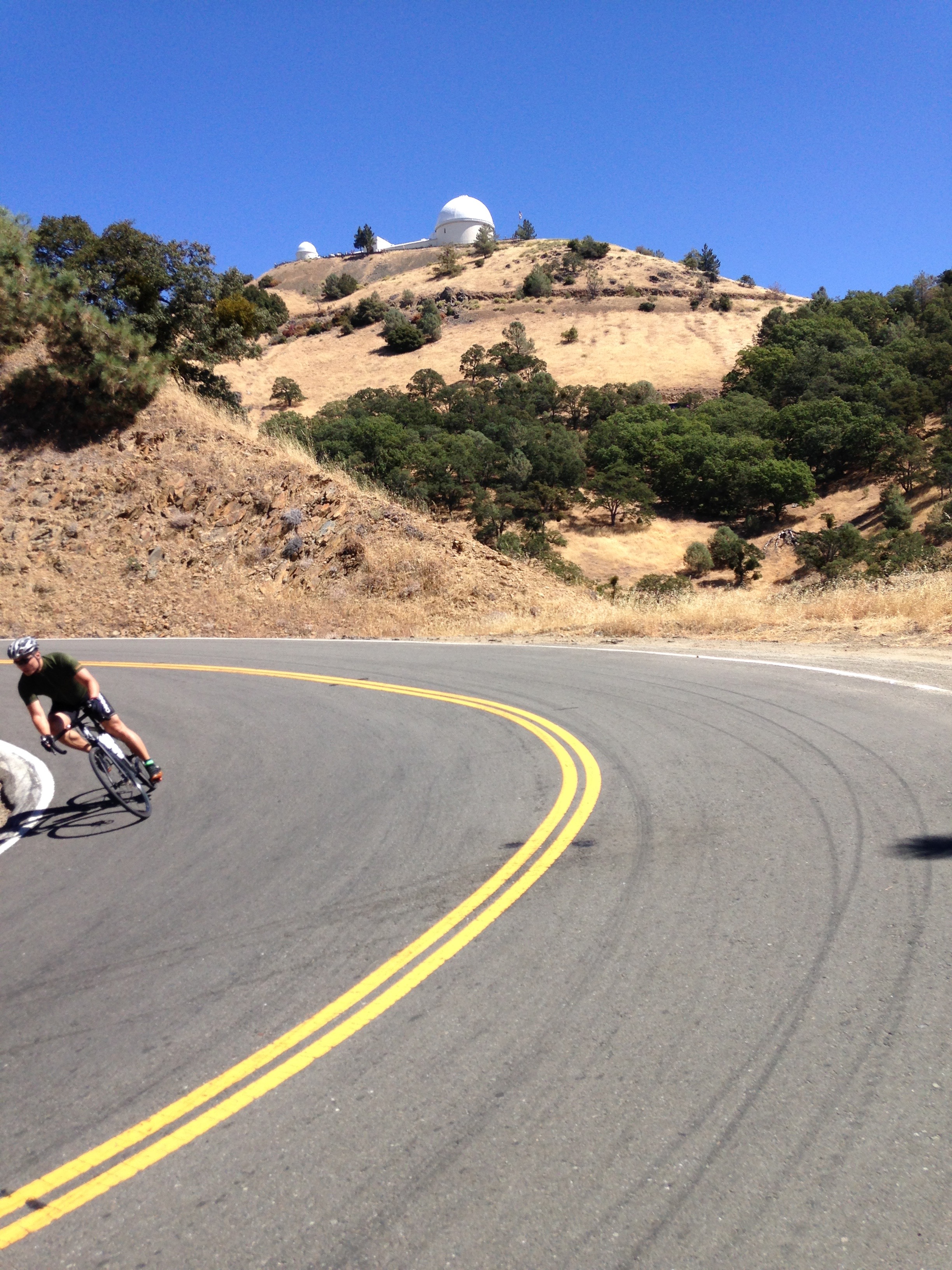 This is a long but good ride with lovely views. The top 6 miles is amazing, with lots of very tight switchbacks. The whole ride, out and back, is 36.8 miles with 4,800 feet of climbing. This popular ride is another of Jay Rawlins’ “Best of the Best” rides.
Start at the intersection of Mt Hamilton Road and Alum Rock Ave. You will often see many cars parked here. I saw about 50 cyclists including 5 tandems when I did this ride.
The road surface varies between good to rough chip-and-seal to silky smooth. But even the rougher parts are wonderful compared to the roads in Sonoma County.
The climb is never too steep, and even includes two long downhills. At about 6 miles you get your first view of the Lick Observatory, which seems to be miles away. At 11 miles, everything changes: you see the observatory rearing up ahead of you, the road goes downhill, and the surface changes to silky smooth. The last 6 miles are wonderful to climb, and even more incredible to descend.
Sierra Road (S-1)
 This ride is only about 3 miles from the start of Mt Hamilton and I read about it on Jay Rawlins’ site. So after riding Mt Hamilton I drove over there and just rode the uphill, which is 3.65 miles long with 1,805 feet of climbing. It has some brutally steep 18% sections, but fortunately the climb is stepped so the steep parts don’t last too long.
Start at the intersection of Sierra Road and Piedmont Road. Ride uphill to the top, to the Sierra Vista Open Space Preserve viewpoint.
San Diego
The Six and a Half Faces of Soledad
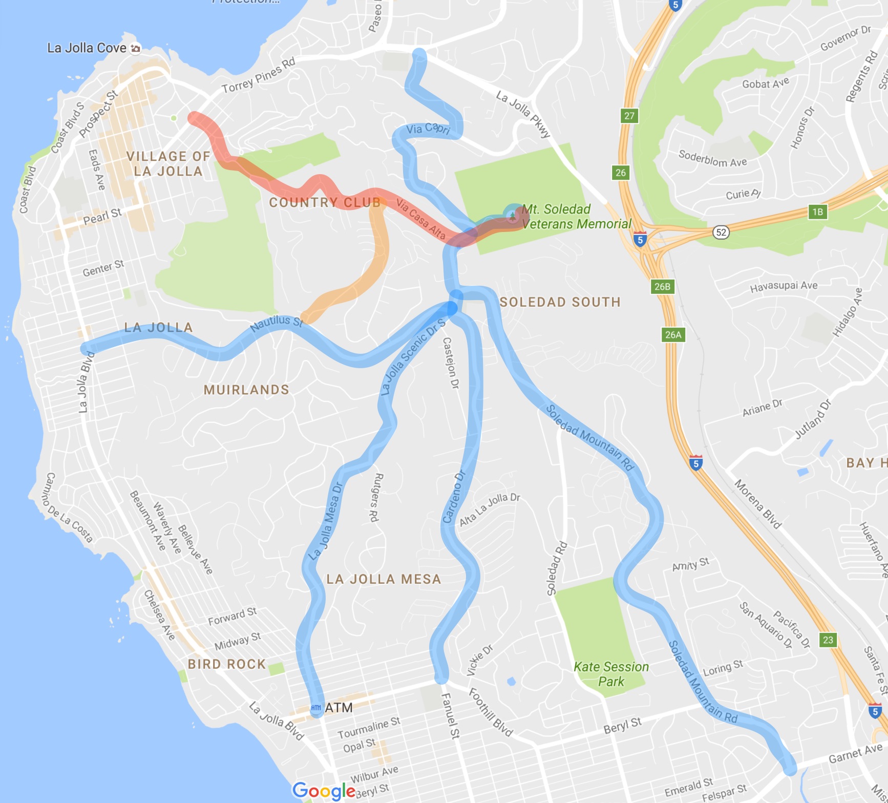 This ride in La Jolla climbs to the top of Mt Soledad and around the cross at the Veterans Memorial Park six and a half times (the half time being a route that doesn’t go fully to the bottom.) This ride is based on the popular 5 Faces of Soledad climb, which you can find by doing a web search.
The ride is a series of out-and-backs from the top and you can obviously start at any of the bottom points. I started at the most northern one as we were staying in La Jolla Shores.
The classic 5 Faces of Soledad is about 25 miles with 3,620 feet of climbing. The 6 1/2 Faces of Soledad is about 32 miles with 4,910 feet of climbing.
On the image above, the blue lines show the classic 5 faces. The red line is the sixth face I rode, and the orange line is the half face, which only goes down until it joins Nautilus St. There are several other routes you can create if you want more, the most obvious being Hillside Drive.
Four of the routes share the last 0.6 miles to the Memorial, so you’ll be repeating part of the ride multiple times. I did the out-and-backs clockwise. Here goes.
- Start at the intersection of Hidden Valley Rd and Torrey Pines Rd. Ride up Hidden Valley Rd and turn right on Via Capri. The gradient reaches 19% on Via Capri. At the top turn left and ride up to and around the Veterans Memorial cross. This is the shortest and steepest route.
- Head south on La Jolla Scenic Drive to the first traffic light. Turn left and ride down Soledad Mountain Rd to the bottom at Garnet Ave. Ride back up and around the cross. This is the longest and generally easiest route, although there are three short sections of 8%.
- Head south on La Jolla Scenic Drive to the second traffic light. Turn left on Cardeno Drive and ride down to Turquoise Street. Ride back up and around the cross. There is a nice section of 8% on this climb.
- Head south on La Jolla Scenic Drive to the second traffic light. Continue straight down La Jolla Scenic Drive to the T-junction. Turn right then turn left on La Jolla Mesa Drive and continue down to Turquoise Street. Ride back up and around the cross. There is some nice 9-10% near the bottom.
- Head south on La Jolla Scenic Drive to the second traffic light. Turn right and ride down Nautilus Street to La Jolla Blvd. Ride back up and around the cross. The road above Muirlands Drive is beautifully paved and a delight to ride, and has a nice 8-9% section. You have now done the classic 5 Faces of Soledad.
- This is the half face. Head down La Jolla Scenic Drive for a very short way then at the red and white radio towers, turn right on Via Casa Alta. After a gentle climb, descend very steeply to Upper Hillside. Turn left and head down Caminito Valverde and Via Valverde to Nautilus Street. (I love that this road is called Valverde after one of my cycling heroes 🙂 ) Ride back up and around the cross. Valverde has some sections of 14% and Via Casa Alta has some 15%.
- Head down La Jolla Scenic Drive for a very short way then at the red and white radio towers, turn right on Via Casa Alta. After a gentle climb, descend very steeply to Upper Hillside. Facing you is a gate with the sign 7242 Encilia. At the left side of the big gate is a small gate for pedestrians and cyclists. Go through this, ride down the private road, and find the the small gate at the left side of the lower big gate. Ride down Upper Hillside Drive, Encilia Drive, Brodiaea Way, Romero Drive, Country Club Drive, Exchange Place to Torrey Pines Rd. Ride back up and around the cross. There are several steep sections, including 14% on Brodiaea Way and 15% on Via Casa Alta.
- Descend back down Via Capri and Hidden Valley Road.
(Interestingly, the big cross at the Mt Soledad Veterans Memorial is mired in controversy because of the First Amendment separation of church and state. Courts have several times ordered it to be removed.)
Great Western Loop
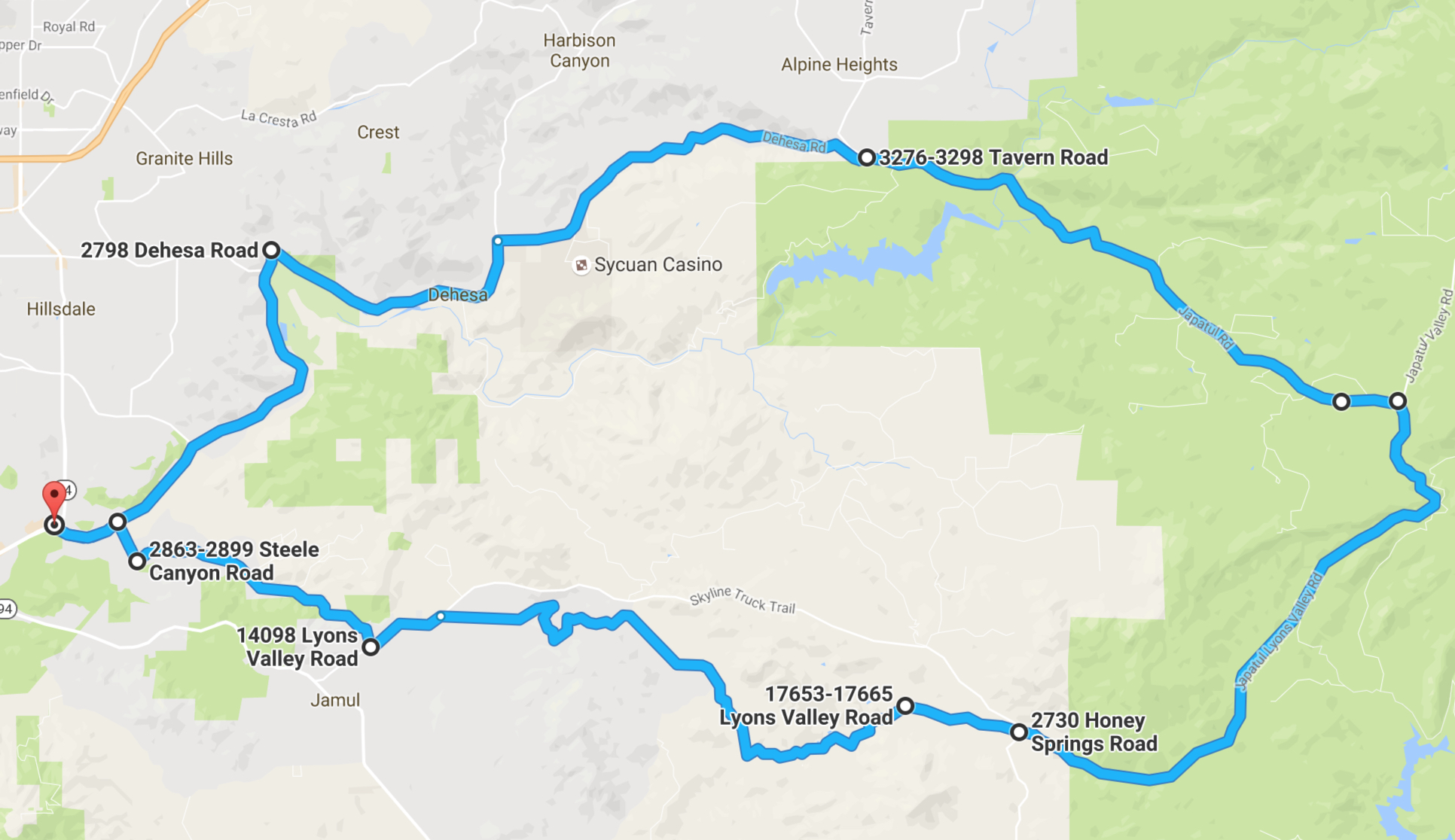 A very popular loop in eastern San Diego County, this is a wonderful ride, varied and interesting, with ever changing scenery. The loop is usually ridden clockwise.
The route is mainly obvious, but there are a few places where it helps to know what to do.
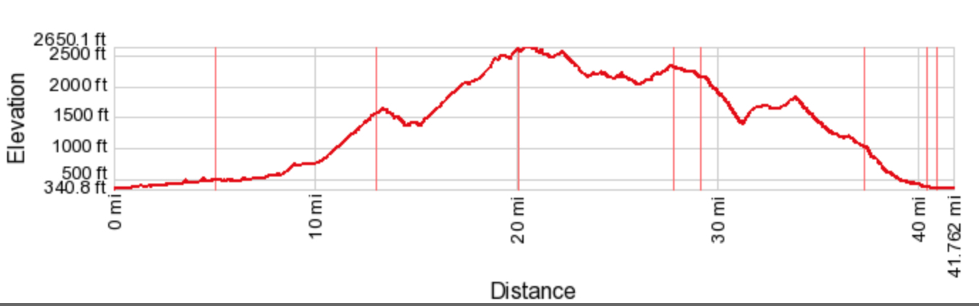 At 41.7 miles with 3,638 feet of climbing, the Great Western Loop basically rolls uphill for the first half and rolls downhill for the second half.
 Park in the shopping center by the intersection of Jamacha Road and Willow Glen Drive, in Rancho San Diego. The distances shown here start at this intersection. They are mainly based on Google maps because this area has strange magical qualities: after about 30 miles my Garmin 500 suddenly started showing that I had ridden 557 miles.
- 5.0 miles, turn right on Dehesa Road.
- 8.3 miles, at the 3-way stop, turn right to stay on Dehesa Road.
- 13.1 miles, turn right on Japatul Road. This next section is delicious – mainly uphill, lovely scenery, and you can see the road winding and climbing ahead of you.
- 20.1 miles, turn right on Lyons Valley Road, and start heading downhill. This next section feels remote, and is spectacular, with lovely views of hills covered with rocks.
- 27.8 miles, at the intersection with Skyline TT continue straight. The next section is narrower and twistier.
- 29.5 miles, you start a steep twisty downhill section that ends up in a beautiful rock filled valley. But all good downhills end, and you are faced with a brutally steep little hill to exit.
- 33.6 miles, turn left at stop sign.
- 34.2 miles, start another lovely twisty downhill.
- 36.4 miles, turn left at the T-junction
- 37.3 miles, turn right on Jamul Drive. Pay attention or you’ll miss the turn.
- 40.4 miles, turn right on Steele Canyon Road.
- 40.9 miles, turn left on Willow Glen Drive.
- 41.7 miles, back to Jamacha Road and the finish.
Note: if you need water on the route, turn left at mile 13.1 on Tavern Road and ride up for 0.5 miles. At the first house on the right there’s a triangle garden with a tap in the middle of the triangle. At mile 29.1 you’ll find the Lyons Valley Trading Post.
Pacific Coast Highway
 This is a popular ride from La Jolla, heading north through Torrey Pines and UCSD, to Del Mar and back. You can go further but it gets less interesting beyond Del Mar. As described, it’s a 17.6 mile roundtrip, with 1,240 feet of climbing.
Start at the intersection of Torrey Pines Road and La Jolla Shores Drive. Ride north on La Jolla Shores Drive, climbing up through two switchbacks past the Scripps Institute of Oceanography. At the traffic light, turn left on Torrey Pines Road and follow this to a second traffic light. Turn left again and follow Torrey Pines Road to a beautiful, long downhill. At the bottom of this you pass the lovely Torrey Pines State Beach before another climb takes up and over to Del Mar. Ride through Del Mar until you get bored and decide to turn back.
Riding back, you climb the wonderful hill out of the State Beach. Never too steep, this is a great hill to power up; some cyclists use it to ride hill repeats.
(As you ride through Del Mar you’ll see several steep roads leading away from the sea; in particular, Del Mar Heights Road is a fun little climb that leads to a neighborhood to its south that has several steep little roads to explore.)
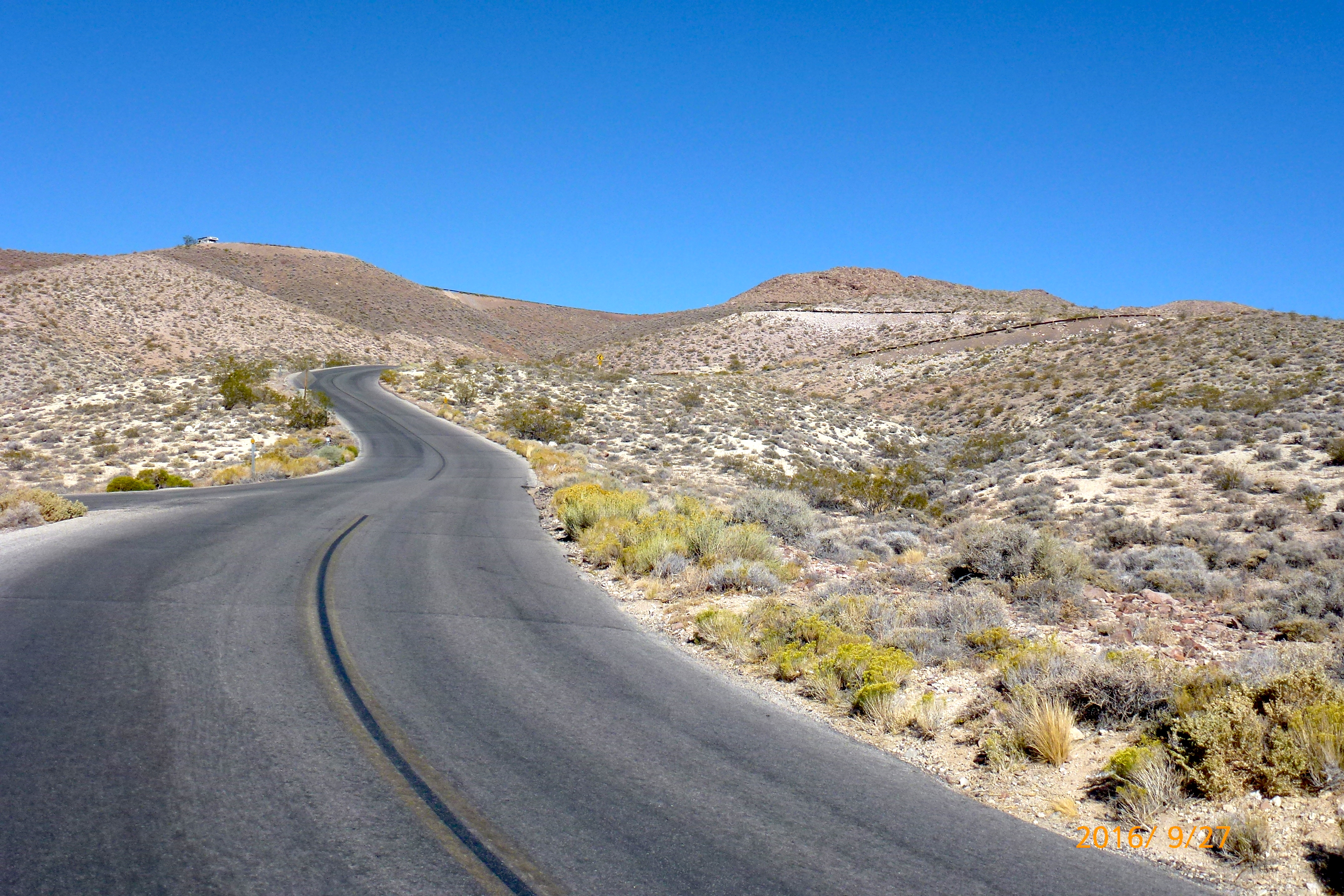
Death Valley
Townes Pass East (#36, S-HC/1)
 The east side of Townes Pass is a big climb out of Death Valley; it’s also a strange one. The road has so many straight sections and there’s so little change in the scenery, that you wonder why bother? I suppose because you are passing through Death Valley and it’s a big climb. Personally I preferred the west side of Townes Pass (#84, S-1), which is more twisty and interesting – and shorter. The east side climb is 14.5 miles with 4,723 feet of climbing.
I was coming over from Lone Pine so I simply parked in the Brake Check area at the top of the pass and rode down 14.5 miles to where the road flattens, just before it climbs slightly. Otherwise you are probably best off parking at Stovepipe Wells (lots of parking) and riding 2.2 miles to the dip in the road where the climb starts. The ride down seemed endless and I wondered how I could possible ride up that whole distance.
Well, it wasn’t so bad, although it is a bit monotonous with all the straightaways and lack of changing scenery. So here goes: The climb starts gradually and the tedium is relieved briefly at mile 3 with a short downhill. At mile 6.9 there is drinking water and toilets. There is a lot of riding at 6-7% then at mile 9.5 you get some 8%, which increases to 9-10% at about mile 10.8. The last 3 miles or so feel different, with the road wiggling a bit through the hills to the top.
Dante’s View (#68, S-1)
 Dante’s View is a long, boring climb in Death Valley, with a great finish and stunning views from the top. The climb is 25.1 miles and 5,666 feet of climbing.
Start at the Furnace Creek Visitor Center (190 feet below sea level) and ride east along Hwy 190 for 12 miles. The gradient is generally very moderate, and if you start early to beat the heat you will have the sun in your eyes the whole way, which rather takes away from the strange Death Valley scenery. After 12 miles, turn right following signs for Dante’s View. Follow this road easily then at about 19 miles it opens into a big bowl surrounded by hills. The gradient increases to 6-7%, then with about 2 miles to go you get some 11-12%. Finally you reach what looks like the top, only to look up and right and see the real top, with switchbacks leading up to it. Starting this section is the steepest pitch on the climb, at 15%. At the very top you have stunning views of the Badwater valley below.
Other Areas
These are rides done a few years ago, before I was adding greater detail. Sorry.
Shirley Meadows East (#18, S-HC). I found this to be a rather unremarkable climb of 9.9 miles with 4,105 feet of climbing. Steep in places, to be sure, but nothing particularly memorable. But maybe my memory is not so good because Summerson says of it, “It includes one of the most difficult five-mile stretches of climbing in the United States along multiple double-digit ramps…… it is one of the most difficult climbs in the country and some think it may be the most difficult in California.” Well, don’t count me in that group, but as they say, your mileage may vary. (My friend Steve Correll has a very different recollection of the climb, thinking it was really quite hard, so perhaps my memory is just flawed. Certainly Tanya thinks it is.) We stayed in Lake Isabella, which was a mistake, and we should have stayed in Kernville.
Palomar Mountain (#23, S-HC). Summerson describes this as “one of the most difficult climbs in Southern California.” He also says that “this climb is longer and as steep as the standard route up the Galibier.” So you can knock the Col du Galibier off your list 🙂 A fun climb of 13.2 miles with 4,735 feet of climbing. The first mile or so from Pauma Valley are pretty steep, then after a few miles you turn off the main road onto South Grade Road. The climb switchbacks steeply up from here, without too much traffic. A long way from the other climbs but worth doing if you are in the area.
Links and Other Clicks
Yes, I know I showed this link near the top of the page, but here it is again – a wonderful web site that describes what the author considers the best rides in California and Oregon.

Niice share
LikeLike
What a fantastic site. It’s a true hero list. I just discovered it recently an didn’t know if it was still “live”. Imagine by happy surprise with the 2025 update. So great so see you using Ride With GPS now, congrats on the technology buy in. It’s great as it allows us not only to get directional info on your rides, but also allow us to edit (yes, make them easier for mere mortals!) and save them to our chosen nav devices.
LikeLike