
July 2023.
Map showing the location of the rides in Austria described in the page below.
Zell am See
Zell am See is a pretty town on the Zeller See, or Lake Zeller. (It’s a walk of about 11 km around the lake.) Zell is a big tourist destination and is a hub of the international jet set. Besides the skiing in winter, it’s apparently a popular summer vacation spot for wealthy Russians and Arabs, many of whom spend their whole summer in one of the luxury lakefront hotels. Zell is also home to the Porsche family, which has a private estate in the southern part of Zell. So you are likely to see lots of Porsches on the roads around Zell.
From a cycling perspective, Zell am See is the base for cycling the Großglockner, one of the great climbs of Europe.
Großglockner / Edelweißspitze
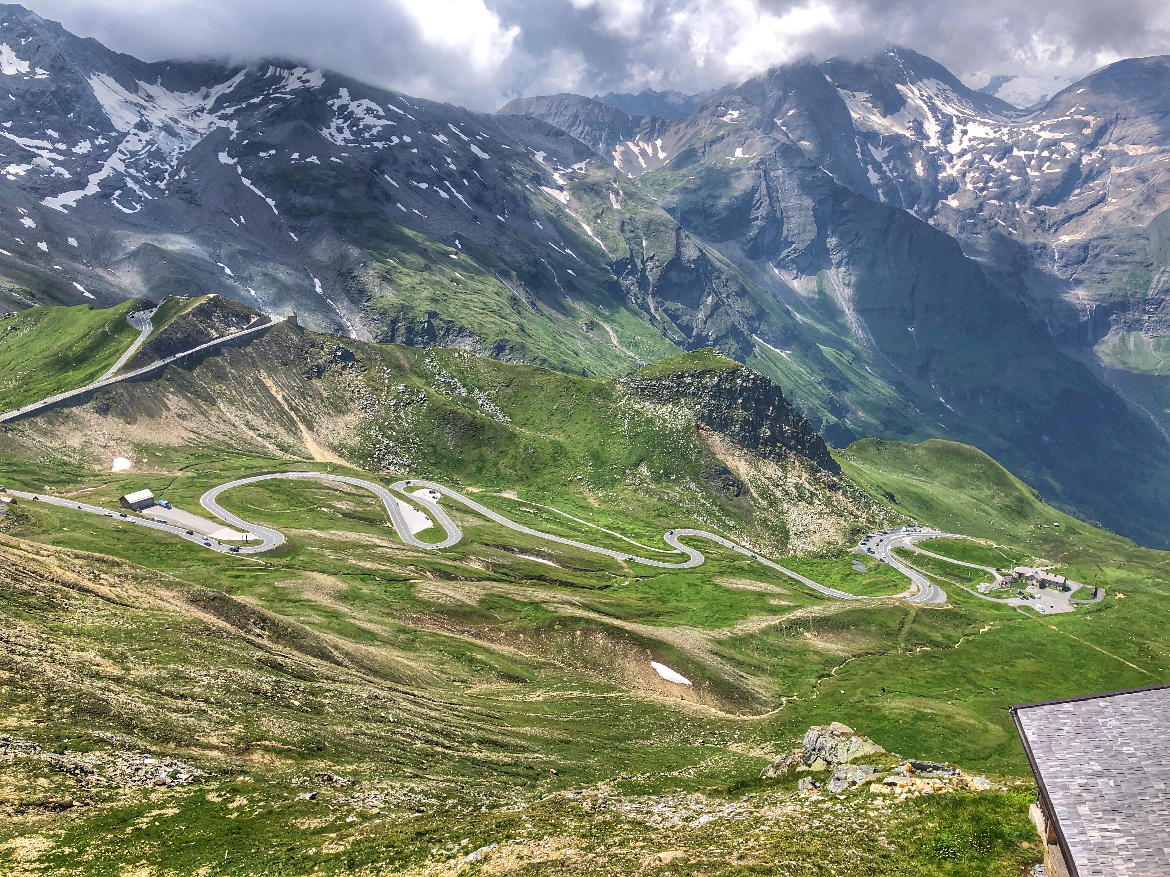 The Großglockner is one of the great climbs of Europe. Will at Cycling Challenge says “This is one of the most beautiful paved roads I’ve ever cycled.” To be fair, he rode it on Bike Day when there were no cars. We rode it on a Sunday, when there were lots of cars. Apparently this road is very popular with Porsches, other cars, and motorcycles at the weekends, so avoid the weekend if possible.
But still, it’s an amazing ride, made even more amazing by the final two kilometers, where you ride up a cobblestone road to the Edelweißspitze. Apart from the initial flat and flattish section, it has a pretty consistent gradient the whole way. We rode from Zell am See, but some people start in Bruck and some in Fusch. For us the round-trip was 64 km with 1,794 meters of climbing.
There seems to be a bike path from Bruck to Fusch, but we didn’t notice it on the way up. Above Fusch, you pass a pay station at about KmM 14.5, but bicycles are free. There’s a special lane for bikes on the right, and you have to stop and press a button, and a barrier opens. I assume they do this to count cyclists.
On the main road up to the Edelweißspitze turn off, there are 14 numbered switchbacks. Once you reach the obvious turnoff, turn left and climb 6 numbered switchbacks of amazing cobblestone road to the Edelweißspitze. Up here there a wonderful views of the mountains (although the Großglockner itself is barely visible), and there’s a restaurant where we relaxed with a coffee and strudel.
Descend back down the cobblestones, then let your bike fly down the main road. This descent is stunning. The road is smooth, the gradient is perfect, and you can fly down with a big smile on your face.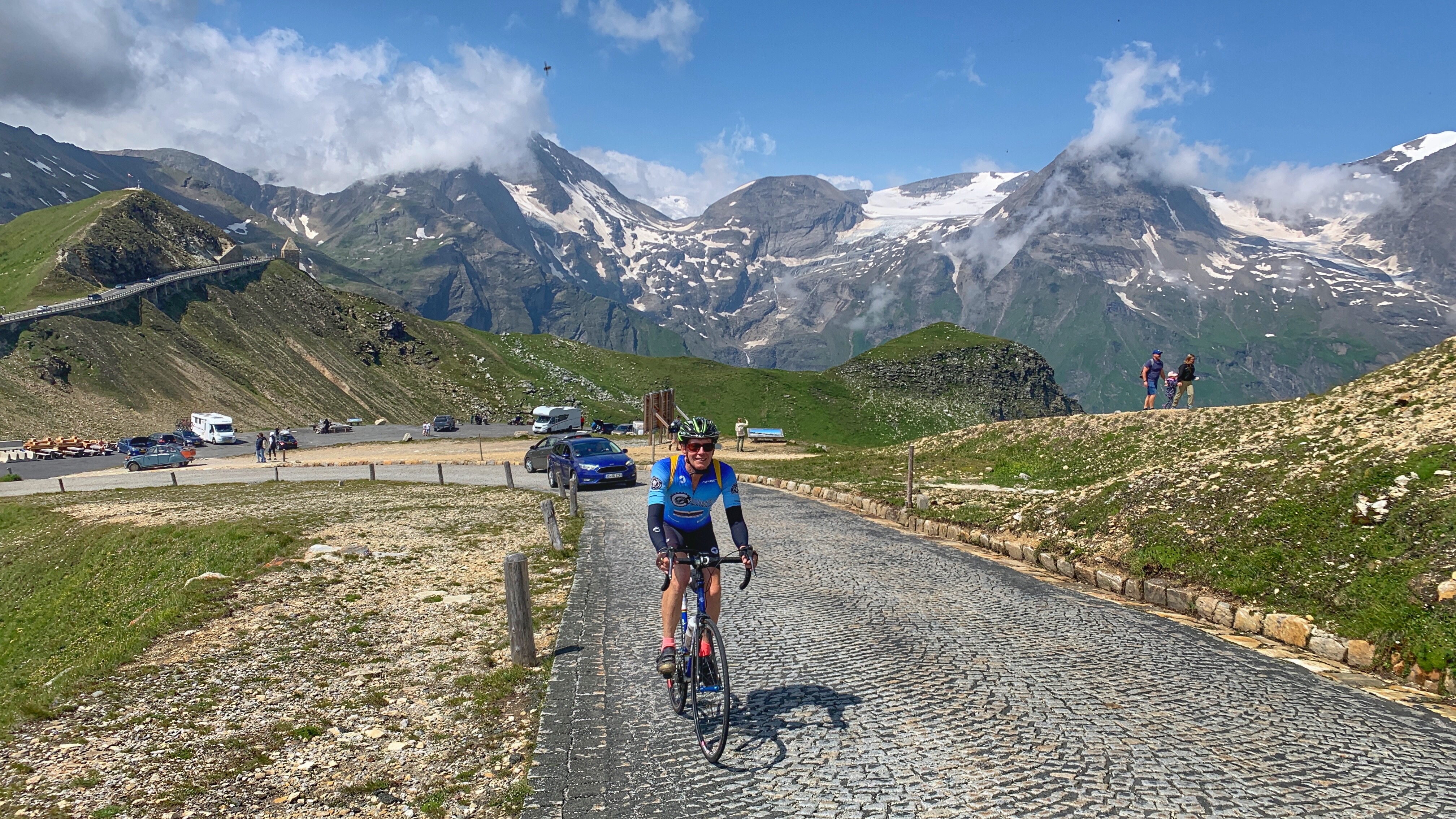
Here’s the ride on Ride with GPS.
Kitzbüheler Horn
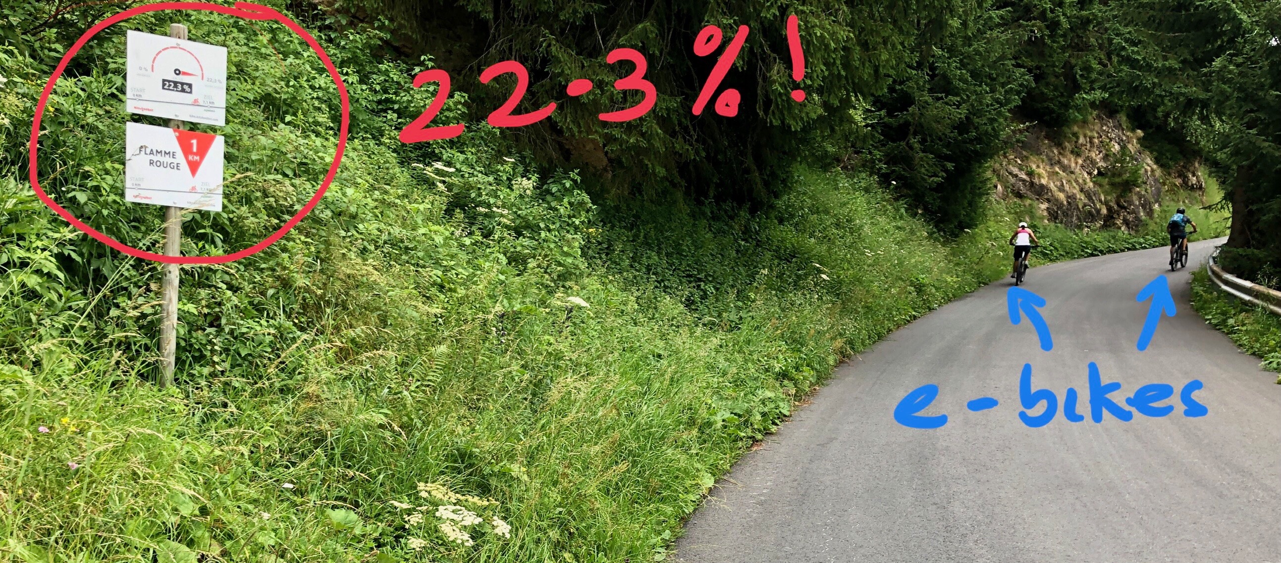 This is a fairly short (10.2 km) climb, but it is steep! Brutally steep! This is one of the tough climbs of Austria. And there are good views. To the tower at the top it’s 10.2 km with 1,201 meters of climbing. The road is very quiet and I was only passed by a few cars, and two couples on e-bikes.
I drove from Zell am See and parked at the base of the climb at 47.465541, 12.386079 – there are five parking spots here for cars.
The road climbs up through a residential area initially, but fortunately where there is a choice of road there are big signs painted on the road saying “HORN” with an arrow telling you which way to go. There’s a pay station fairly near the bottom but foot traffic doesn’t have to pay. I figured I was foot traffic.
You are soon in the countryside and on consistently steep gradients. I stood most of the climb. Probably 50% of the time that I looked at my Karoo it was saying 13.7% 😀.
After 8 km, 17 switchbacks, and 895 meters of climbing you reach the Alpenhaus, and a parking lot. But you are by no means done and you still have another 2.2 km and 10 switchbacks to climb up to the tower at the top.
This upper section is closed to motorized traffic, and there were a lot of people walking on it. I found this section the hardest part of the climb, really steep.
Just before the tower there is a restaurant; stay to the left and do one more switchback to the top.
The climb is so steep that I rode my brakes a lot on the way down, and was worried that my rims would get too hot. Fortunately I made it down safely 😀.
Here’s the ride on Ride with GPS.
Sölden
Sölden is very much an outdoor activities town: skiing in winter and hiking and mountain biking in summer. Many of the places to stay give you a Summer Card which gives you free rides on the chairlifts and various buses, and access to several swimming areas. The town doesn’t have much charm, and one curious thing is the number of strip clubs / table dancing nightclubs, which I guess tells you something about the clientele the town expects in winter.
You’ll see a reasonable number of road cyclists, most of whom are there to ride the Rettenbachferner, but the vast majority of people with bicycles are mountain bikers who take the lifts up and come down the beautiful wiggly mountain bike trails.
Rettenbachferner

Another brutally steep climb. Soigneur magazine compares it to Italy’s Zoncolan and Spain’s Angliru. The ride from Sölden and back is 29.4 km with 1,400 meters of climbing.
Starting in the center of Sölden, ride southwards and up for about 2 km to where the road to Rettenbachgletscher and Tiefenbachgletscher turns right. This is the start of the big climb. 4 switchbacks through trees lead to the toll station; bikes are free.
Now you are above treeline and can see up the valley to the ski buildings, just below the glacier itself. 4 more switchbacks lead to marginally easier gradients, until you reach the ski buildings. Now you take the road on the right, signed to P1 and P2. This is where things get even harder, and for the next 1.2 km you’ll be riding the most difficult part of the climb.
Finally, thankfully, you reach a large flat parking area with a sign saying this is the highest road in the EU (which it isn’t).

Here’s the route on Ride with GPS.
Timmelsjoch / Passo Rombo
I didn’t ride this, but while we were in Sölden, my friend Marcus rode from Sölden, over the pass, down to San Leonardo, and back. He reported that the whole ride was 102 km with 3,200 meters of climbing.
Marcus also reported that the Italian side is the better climb, that it has 18 numbered tunnels(!), and that the section between San Leonardo to Moos is not very interesting but from Moos to the pass is very good.
Links and Other Clicks
Here’s Soigneur magazine’s web page that writes about Cycling Austria’s Best Climbs.
Here’s a gradient profile for the Großglockner / Edelweißspitze climb from Fusch.
You can see gradient profiles for Kitzbüheler Horn here and here and here.
You can see gradient profiles for Rettenbachferner here and here and here.
Here’s a gradient profile for Timmelsjoch/Passo Rombo from San Leonardo. And a profile from Sölden.
Here’s a page with some nice photos of the Timmelsjoch/Passo Rombo.
